MTB Weg der Blicke V1
- 42.4 km
- 1,453 m
- 1,453 m
- Lemgo, North Rhine-Westphalia, Germany
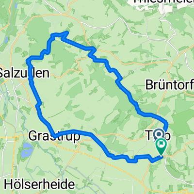
A cycling route starting in Lemgo, North Rhine-Westphalia, Germany.
Overview
Short MTB tour through the Lemgo city forest with access via Voßheide, Maibolte. Loop around the Windelstein. Return via Dörentrup and Papiernbentrup.
Route length: 31.51 kilometers
Average speed: 15.4 Km/h
Calorie consumption: 1879 Kcal (variable)
Active riding time: 2 hours 31 minutes
Maximum speed: 37.1 Km/h
Total ascent: 590 meters
Total descent: 595 meters
Maximum elevation: 298 meters
Starting elevation: 110 meters (for 32657 Lemgo)
created this 8 years ago
Route quality
Track
20.2 km
(64 %)
Path
4.4 km
(14 %)
Paved
13.6 km
(43 %)
Unpaved
14.5 km
(46 %)
Gravel
14.5 km
(46 %)
Asphalt
13.2 km
(42 %)
Continue with Bikemap
You would like to ride Kleine Mtb Tour im Lemgoer Stadtwald or customize it for your own trip? Here is what you can do with this Bikemap route:
Free trial for 3 days, or one-time payment. More about Bikemap Premium.
Discover more Premium features.
Get Bikemap PremiumFrom our community
Open it in the app