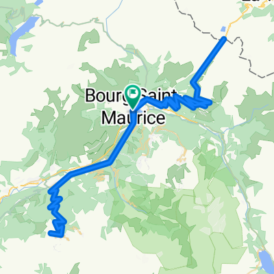
2017 ALPS Etapa 4 - Cormet de Roselend
A cycling route starting in Bourg-Saint-Maurice, Auvergne-Rh么ne-Alpes, France.
Overview
About this route
- -:--
- Duration
- 93.2 km
- Distance
- 2,244 m
- Ascent
- 2,519 m
- Descent
- ---
- Avg. speed
- ---
- Max. altitude
Route quality
Waytypes & surfaces along the route
Waytypes
Quiet road
2.8 km
(3 %)
Access road
0.9 km
(1 %)
Surfaces
Paved
69 km
(74 %)
Unpaved
0.9 km
(1 %)
Asphalt
69 km
(74 %)
Ground
0.9 km
(1 %)
Undefined
23.3 km
(25 %)
Route highlights
Points of interest along the route
Point of interest after 19.5 km
Cormet de Roselend 19km 6% 8,9% 1154 m http://www.cols-cyclisme.com/beaufortain/france/cormet-de-roselend-depuis-bourg-saint-maurice-c147.htm
Point of interest after 27.9 km
Col de M茅raillet
Point of interest after 58.3 km
Col de Saisies 19km 6,3% 11%mx 957 m http://www.cols-cyclisme.com/beaufortain/france/col-des-saisies-depuis-d925-d218-c635.htm
Continue with Bikemap
Use, edit, or download this cycling route
You would like to ride 2017 ALPS Etapa 4 - Cormet de Roselend or customize it for your own trip? Here is what you can do with this Bikemap route:
Free features
- Save this route as favorite or in collections
- Copy & plan your own version of this route
- Split it into stages to create a multi-day tour
- Sync your route with Garmin or Wahoo
Premium features
Free trial for 3 days, or one-time payment. More about Bikemap Premium.
- Navigate this route on iOS & Android
- Export a GPX / KML file of this route
- Create your custom printout (try it for free)
- Download this route for offline navigation
Discover more Premium features.
Get Bikemap PremiumFrom our community
Other popular routes starting in Bourg-Saint-Maurice
- Tag 7
- Distance
- 122.8 km
- Ascent
- 2,011 m
- Descent
- 2,107 m
- Location
- Bourg-Saint-Maurice, Auvergne-Rh么ne-Alpes, France
- RdGA - Stage 3 (Var. Mont Cenis finish Moncenisio)
- Distance
- 112.4 km
- Ascent
- 2,791 m
- Descent
- 2,173 m
- Location
- Bourg-Saint-Maurice, Auvergne-Rh么ne-Alpes, France
- 2017 ALPS ETAPA 1 - Iseran-savonne
- Distance
- 110.9 km
- Ascent
- 2,717 m
- Descent
- 2,720 m
- Location
- Bourg-Saint-Maurice, Auvergne-Rh么ne-Alpes, France
- Day 4 BSM to Geneva
- Distance
- 145.1 km
- Ascent
- 1,847 m
- Descent
- 2,283 m
- Location
- Bourg-Saint-Maurice, Auvergne-Rh么ne-Alpes, France
- Tour de France 2009, Etappe 17 - 169,5 km
- Distance
- 169.5 km
- Ascent
- 3,968 m
- Descent
- 3,968 m
- Location
- Bourg-Saint-Maurice, Auvergne-Rh么ne-Alpes, France
- Col du Petit Saint-Bernard
- Distance
- 105.6 km
- Ascent
- 2,537 m
- Descent
- 2,537 m
- Location
- Bourg-Saint-Maurice, Auvergne-Rh么ne-Alpes, France
- Albertville - Roseland - Runde
- Distance
- 136.2 km
- Ascent
- 2,793 m
- Descent
- 2,782 m
- Location
- Bourg-Saint-Maurice, Auvergne-Rh么ne-Alpes, France
- 2017 ALPS Col de l'Iseran a
- Distance
- 147.7 km
- Ascent
- 3,138 m
- Descent
- 3,138 m
- Location
- Bourg-Saint-Maurice, Auvergne-Rh么ne-Alpes, France
Open it in the app