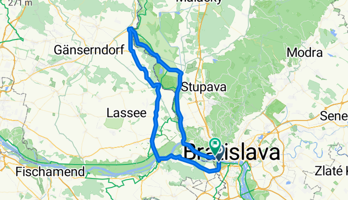
Bratislava Angern und zurück
A cycling route starting in Bratislava, Bratislavský kraj, Slovak Republic.
Overview
About this route
Trasa začína klasicky pod mostom Lafranconi, pokračuje cez prechod Berg po cyklotrase do Hainburgu. Tam je zástavočka v Donau cafe restaurant. Pokračuje sa po nábreží k mostu cez dunaj a potom to už vedie len po okrskách cez Marcheg do Angernu kde je kompa do Záhorkej Vsi. No a potom už len po hrádzi popri morave cez Vysokú do Devína.
- -:--
- Duration
- 84.6 km
- Distance
- 103 m
- Ascent
- 102 m
- Descent
- ---
- Avg. speed
- ---
- Avg. speed
Route highlights
Points of interest along the route
Point of interest after 14.1 km
DONAU CAFE - RESTAURANT
Point of interest after 46.8 km
KOMPA
Point of interest after 75.8 km
DEVÍN
Continue with Bikemap
Use, edit, or download this cycling route
You would like to ride Bratislava Angern und zurück or customize it for your own trip? Here is what you can do with this Bikemap route:
Free features
- Save this route as favorite or in collections
- Copy & plan your own version of this route
- Sync your route with Garmin or Wahoo
Premium features
Free trial for 3 days, or one-time payment. More about Bikemap Premium.
- Navigate this route on iOS & Android
- Export a GPX / KML file of this route
- Create your custom printout (try it for free)
- Download this route for offline navigation
Discover more Premium features.
Get Bikemap PremiumFrom our community
Other popular routes starting in Bratislava
- Milanova80tka
- Distance
- 74.9 km
- Ascent
- 48 m
- Descent
- 48 m
- Location
- Bratislava, Bratislavský kraj, Slovak Republic
- na Veľký Javorník a späť
- Distance
- 39.4 km
- Ascent
- 550 m
- Descent
- 550 m
- Location
- Bratislava, Bratislavský kraj, Slovak Republic
- okolo Hundsheimeru
- Distance
- 43 km
- Ascent
- 218 m
- Descent
- 210 m
- Location
- Bratislava, Bratislavský kraj, Slovak Republic
- Bratislava - Vojka
- Distance
- 63.4 km
- Ascent
- 48 m
- Descent
- 50 m
- Location
- Bratislava, Bratislavský kraj, Slovak Republic
- Popri rieke Morave
- Distance
- 106.3 km
- Ascent
- 127 m
- Descent
- 127 m
- Location
- Bratislava, Bratislavský kraj, Slovak Republic
- poobedňajšia 50ka BA-Bernolákovo a späť
- Distance
- 50.3 km
- Ascent
- 47 m
- Descent
- 47 m
- Location
- Bratislava, Bratislavský kraj, Slovak Republic
- Žltá, Bratislava V to Fialová, Bratislava V
- Distance
- 10.8 km
- Ascent
- 104 m
- Descent
- 96 m
- Location
- Bratislava, Bratislavský kraj, Slovak Republic
- Okolo Hainburgských vŕškov
- Distance
- 41 km
- Ascent
- 177 m
- Descent
- 178 m
- Location
- Bratislava, Bratislavský kraj, Slovak Republic
Open it in the app