

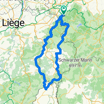
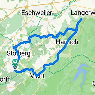
Aachen-Venn-Eifel 85km-1080Hm
A cycling route starting in Stolberg, North Rhine-Westphalia, Germany.
Overview
About this route
Schöne Rennradroute von Aachen-Brand durch das Hohe Venn und die Eifel.
Von Brand nach Lichtenbusch, weiter über kleine Straßen zur Wesertalsperre. Weiter über die Monschauer Straße nach Mützenich auf über 600m. Der Ausblick auf das ursprüngliche Venn entschädigt uns für den schlechten Asphalt.
Dann über Paustenbach und Simmerath runter ins malerische Simonskall und sofort wieder hoch. Hier müssen wir leider ein Stück die vielbafahrene B399 nehmen, bevor wir auf die L24 abbiegen, die uns nach Zweifall bringt. Nun noch einmal hoch hinauf nach Breinig.Nun noch über Dorff nach Krauthausen, wo uns der letzte Berg erwartet. Die Tour endet an der Freunder Landsträße nicht weit vom Ausgangspunkt.
ca, 85km 1080Hm
- -:--
- Duration
- 83 km
- Distance
- 809 m
- Ascent
- 812 m
- Descent
- ---
- Avg. speed
- ---
- Max. altitude
Continue with Bikemap
Use, edit, or download this cycling route
You would like to ride Aachen-Venn-Eifel 85km-1080Hm or customize it for your own trip? Here is what you can do with this Bikemap route:
Free features
- Save this route as favorite or in collections
- Copy & plan your own version of this route
- Split it into stages to create a multi-day tour
- Sync your route with Garmin or Wahoo
Premium features
Free trial for 3 days, or one-time payment. More about Bikemap Premium.
- Navigate this route on iOS & Android
- Export a GPX / KML file of this route
- Create your custom printout (try it for free)
- Download this route for offline navigation
Discover more Premium features.
Get Bikemap PremiumFrom our community
Other popular routes starting in Stolberg
 Promenade 5a nach Stadtstraße
- Distance
- 28.5 km
- Ascent
- 395 m
- Descent
- 256 m
- Location
- Stolberg, North Rhine-Westphalia, Germany
 Venwegen-St. Vith-Stavelot- Venwegen
- Distance
- 209.9 km
- Ascent
- 2,659 m
- Descent
- 2,659 m
- Location
- Stolberg, North Rhine-Westphalia, Germany
 Aachen-Venn-Eifel 85km-1080Hm
- Distance
- 83 km
- Ascent
- 809 m
- Descent
- 812 m
- Location
- Stolberg, North Rhine-Westphalia, Germany
 Wnd 9,4km Kornelimünster
- Distance
- 9.4 km
- Ascent
- 169 m
- Descent
- 169 m
- Location
- Stolberg, North Rhine-Westphalia, Germany
 Route in Stolberg (Rheinland)
- Distance
- 32.3 km
- Ascent
- 432 m
- Descent
- 437 m
- Location
- Stolberg, North Rhine-Westphalia, Germany
 Kleine Drei-Länder-Tour
- Distance
- 65.8 km
- Ascent
- 420 m
- Descent
- 472 m
- Location
- Stolberg, North Rhine-Westphalia, Germany
 Kornelimunster to Bahnhofplatz, Aachen
- Distance
- 20 km
- Ascent
- 137 m
- Descent
- 196 m
- Location
- Stolberg, North Rhine-Westphalia, Germany
 MTB Breinigerberg
- Distance
- 25.4 km
- Ascent
- 251 m
- Descent
- 249 m
- Location
- Stolberg, North Rhine-Westphalia, Germany
Open it in the app