
Palintang via Ujung berung
A cycling route starting in Cileunyi, West Java, Indonesia.
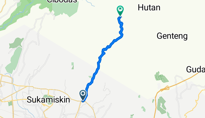
Overview
About this route
Start altitude: 697 metres
End altitude: 1515 metres
Maximum altitude: 1559 metres
Minimum altitude: 697 metres
Distance: 10.7 km
Total ascent: 954 metres
Total descent: 135 metres
Maximum gradient ascending: 27% at 9.5 km
Maximum gradient descending: 20% at 10.4 km
- -:--
- Duration
- 10.7 km
- Distance
- 871 m
- Ascent
- 72 m
- Descent
- ---
- Avg. speed
- ---
- Max. altitude

Route quality
Waytypes & surfaces along the route
Waytypes
Road
10.7 km
(100 %)
Quiet road
0 km
(<1 %)
Undefined
0 km
(<1 %)
Surfaces
Unpaved
0 km
(<1 %)
Unpaved (undefined)
0 km
(<1 %)
Undefined
10.7 km
(100 %)
Continue with Bikemap
Use, edit, or download this cycling route
You would like to ride Palintang via Ujung berung or customize it for your own trip? Here is what you can do with this Bikemap route:
Free features
- Save this route as favorite or in collections
- Copy & plan your own version of this route
- Sync your route with Garmin or Wahoo
Premium features
Free trial for 3 days, or one-time payment. More about Bikemap Premium.
- Navigate this route on iOS & Android
- Export a GPX / KML file of this route
- Create your custom printout (try it for free)
- Download this route for offline navigation
Discover more Premium features.
Get Bikemap PremiumFrom our community
Other popular routes starting in Cileunyi
 GGB BadUt
- Distance
- 66.6 km
- Ascent
- 1,266 m
- Descent
- 1,661 m
- Location
- Cileunyi, West Java, Indonesia
 Jalan Cigiringsing No 6, Kecamatan Ujung Berung to Jalan Cigiringsing No 6, Kecamatan Ujung Berung
- Distance
- 7.5 km
- Ascent
- 2 m
- Descent
- 0 m
- Location
- Cileunyi, West Java, Indonesia
 Road to Cilengkrang
- Distance
- 12.2 km
- Ascent
- 1,946 m
- Descent
- 1,674 m
- Location
- Cileunyi, West Java, Indonesia
 Jalan Sentra Raya Barat, Kecamatan Gedebage to Jalan Sor GBLA, Kecamatan Gedebage
- Distance
- 7.7 km
- Ascent
- 32 m
- Descent
- 35 m
- Location
- Cileunyi, West Java, Indonesia
 Kiara Payung
- Distance
- 5.5 km
- Ascent
- 260 m
- Descent
- 15 m
- Location
- Cileunyi, West Java, Indonesia
 LEMBANG VIA PALINTANG
- Distance
- 27.7 km
- Ascent
- 1,069 m
- Descent
- 530 m
- Location
- Cileunyi, West Java, Indonesia
 Cross-Country Short Circuit Pusperkim
- Distance
- 1.5 km
- Ascent
- 0 m
- Descent
- 0 m
- Location
- Cileunyi, West Java, Indonesia
 Cipadung, Kecamatan Cibiru to Jalan Mohammad Toha 81b, Kecamatan Regol
- Distance
- 18.5 km
- Ascent
- 68 m
- Descent
- 120 m
- Location
- Cileunyi, West Java, Indonesia
Open it in the app