

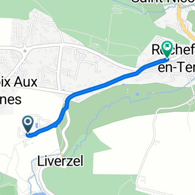
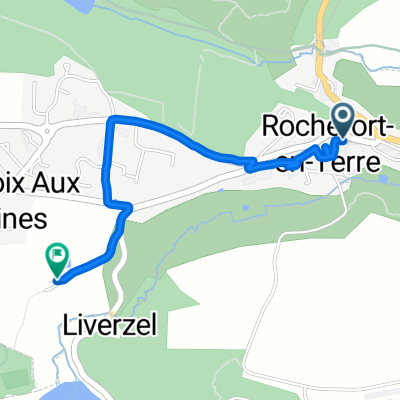
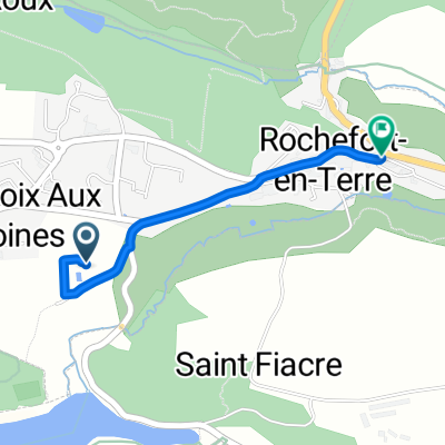
16/05*-ROCHEFORT EN TERRE/AURAY 59.84
A cycling route starting in Pluherlin, Brittany Region, France.
Overview
About this route
OUTRA OPCAO SERIA DESCER EM LE POTEAU PARA LOHENVEN E PLOUGOUMELEN, OU EM VANNES DESCER PELA D21, PASSAR POR PLOEREN, PLOUGOUMELEN E RETORNANDO PARA A D 765
- -:--
- Duration
- 60.7 km
- Distance
- 250 m
- Ascent
- 267 m
- Descent
- ---
- Avg. speed
- ---
- Max. altitude

Route quality
Waytypes & surfaces along the route
Waytypes
Quiet road
19.1 km
(31 %)
Road
14.7 km
(24 %)
Surfaces
Paved
29.4 km
(48 %)
Unpaved
4.3 km
(7 %)
Asphalt
29 km
(48 %)
Ground
2 km
(3 %)
Continue with Bikemap
Use, edit, or download this cycling route
You would like to ride 16/05*-ROCHEFORT EN TERRE/AURAY 59.84 or customize it for your own trip? Here is what you can do with this Bikemap route:
Free features
- Save this route as favorite or in collections
- Copy & plan your own version of this route
- Sync your route with Garmin or Wahoo
Premium features
Free trial for 3 days, or one-time payment. More about Bikemap Premium.
- Navigate this route on iOS & Android
- Export a GPX / KML file of this route
- Create your custom printout (try it for free)
- Download this route for offline navigation
Discover more Premium features.
Get Bikemap PremiumFrom our community
Other popular routes starting in Pluherlin
 4 Rue de la Fontaine aux Bretons, Pluherlin à 4 Rue de la Fontaine aux Bretons, Pluherlin
- Distance
- 14.6 km
- Ascent
- 98 m
- Descent
- 97 m
- Location
- Pluherlin, Brittany Region, France
 Supersonic route
- Distance
- 1.4 km
- Ascent
- 54 m
- Descent
- 68 m
- Location
- Pluherlin, Brittany Region, France
 Bretagne-5.Tag-1-2015.gpx
- Distance
- 50.3 km
- Ascent
- 222 m
- Descent
- 265 m
- Location
- Pluherlin, Brittany Region, France
 2 Rue Haute Candre, Rochefort-en-Terre à Chemin de l'Écluse, Malestroit
- Distance
- 29.5 km
- Ascent
- 210 m
- Descent
- 242 m
- Location
- Pluherlin, Brittany Region, France
 Restful route
- Distance
- 2.2 km
- Ascent
- 52 m
- Descent
- 36 m
- Location
- Pluherlin, Brittany Region, France
 Rue du Porche, Rochefort-en-Terre to Rue des Roseaux, Malansac
- Distance
- 6.2 km
- Ascent
- 62 m
- Descent
- 36 m
- Location
- Pluherlin, Brittany Region, France
 Chemin du Bogeais to Rue Saint-Michel
- Distance
- 1.4 km
- Ascent
- 15 m
- Descent
- 29 m
- Location
- Pluherlin, Brittany Region, France
 16/05*-ROCHEFORT EN TERRE/AURAY 59.84
- Distance
- 60.7 km
- Ascent
- 250 m
- Descent
- 267 m
- Location
- Pluherlin, Brittany Region, France
Open it in the app