

Vallée de Joux-Mollendruz-La Côte
A cycling route starting in Saint-Cergue, Canton of Vaud, Switzerland.
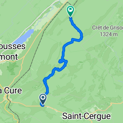
Overview
About this route
Jolie boucle jurassienne sur route uniquement, au départ de La Givrine (accessible en train depuis Nyon). Le parcours longe les lacs des Rousses et de Joux avant de rejoindre le vignoble de La Côte par le col du Mollendruz et Aubonne. Fin de balade à Nyon.
Distance : 102 km
Dénivelé positif : 760 m
Altitude maximale : 1228 m (col de La Givrine)
Plus d'informations sur www.europebybike.info
- -:--
- Duration
- 101 km
- Distance
- 478 m
- Ascent
- 1,295 m
- Descent
- ---
- Avg. speed
- ---
- Max. altitude

Route quality
Waytypes & surfaces along the route
Waytypes
Road
39.4 km
(39 %)
Quiet road
23.2 km
(23 %)
Surfaces
Paved
56.6 km
(56 %)
Asphalt
51.5 km
(51 %)
Concrete
3 km
(3 %)
Continue with Bikemap
Use, edit, or download this cycling route
You would like to ride Vallée de Joux-Mollendruz-La Côte or customize it for your own trip? Here is what you can do with this Bikemap route:
Free features
- Save this route as favorite or in collections
- Copy & plan your own version of this route
- Split it into stages to create a multi-day tour
- Sync your route with Garmin or Wahoo
Premium features
Free trial for 3 days, or one-time payment. More about Bikemap Premium.
- Navigate this route on iOS & Android
- Export a GPX / KML file of this route
- Create your custom printout (try it for free)
- Download this route for offline navigation
Discover more Premium features.
Get Bikemap PremiumFrom our community
Other popular routes starting in Saint-Cergue
 St-Cergue-La Barillette?? à Ä„Ω??
- Distance
- 18.1 km
- Ascent
- 876 m
- Descent
- 883 m
- Location
- Saint-Cergue, Canton of Vaud, Switzerland
 Jura ride
- Distance
- 69.3 km
- Ascent
- 909 m
- Descent
- 909 m
- Location
- Saint-Cergue, Canton of Vaud, Switzerland
 sommet baudichone - givrine
- Distance
- 8.1 km
- Ascent
- 187 m
- Descent
- 378 m
- Location
- Saint-Cergue, Canton of Vaud, Switzerland
 2020 - Gorets - J3 - P1
- Distance
- 11.9 km
- Ascent
- 459 m
- Descent
- 366 m
- Location
- Saint-Cergue, Canton of Vaud, Switzerland
 Bourg-en-Bresse - Les Rousses
- Distance
- 179 km
- Ascent
- 1,894 m
- Descent
- 2,728 m
- Location
- Saint-Cergue, Canton of Vaud, Switzerland
 St Cergue - Grutli - Les Fruitieres de Nyon
- Distance
- 24.8 km
- Ascent
- 653 m
- Descent
- 610 m
- Location
- Saint-Cergue, Canton of Vaud, Switzerland
 Crossing borders, Gex, Geneve Switzerland, France
- Distance
- 48.1 km
- Ascent
- 751 m
- Descent
- 1,546 m
- Location
- Saint-Cergue, Canton of Vaud, Switzerland
 St Cergue - Grutli - Les Fruitieres de Nyon
- Distance
- 24.8 km
- Ascent
- 503 m
- Descent
- 506 m
- Location
- Saint-Cergue, Canton of Vaud, Switzerland
Open it in the app