

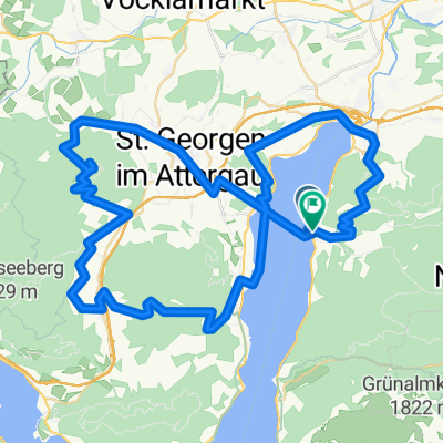
Legends 2017 Tag 1 - Variante 1
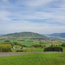
A cycling route starting in Attersee, Upper Austria, Austria.
Overview
About this route
Together: Alexenau-Seewalchen-Gmunden-Ebensee = 45 km (break)
Mitterweißbach-Weißbach-Steinbach-Alexenau = 35 km
Total = 80 km / 500 m elevation gain
- -:--
- Duration
- 78.9 km
- Distance
- 361 m
- Ascent
- 371 m
- Descent
- ---
- Avg. speed
- ---
- Max. altitude

Route quality
Waytypes & surfaces along the route
Waytypes
Road
15 km
(19 %)
Path
11 km
(14 %)
Surfaces
Paved
63.9 km
(81 %)
Unpaved
0.8 km
(1 %)
Asphalt
63.9 km
(81 %)
Gravel
0.8 km
(1 %)
Undefined
14.2 km
(18 %)
Route highlights
Points of interest along the route
Accommodation after 0 km
Hotel
Drinking water after 43.6 km
Mittagspause
Continue with Bikemap
Use, edit, or download this cycling route
You would like to ride Legends 2017 Tag 1 - Variante 1 or customize it for your own trip? Here is what you can do with this Bikemap route:
Free features
- Save this route as favorite or in collections
- Copy & plan your own version of this route
- Sync your route with Garmin or Wahoo
Premium features
Free trial for 3 days, or one-time payment. More about Bikemap Premium.
- Navigate this route on iOS & Android
- Export a GPX / KML file of this route
- Create your custom printout (try it for free)
- Download this route for offline navigation
Discover more Premium features.
Get Bikemap PremiumFrom our community
Other popular routes starting in Attersee
 Runde um den Attersee
- Distance
- 58.6 km
- Ascent
- 481 m
- Descent
- 467 m
- Location
- Attersee, Upper Austria, Austria
 Legends 2017 Tag 1 - Variante 1
- Distance
- 78.9 km
- Ascent
- 361 m
- Descent
- 371 m
- Location
- Attersee, Upper Austria, Austria
 weyreggrunde
- Distance
- 33.5 km
- Ascent
- 697 m
- Descent
- 700 m
- Location
- Attersee, Upper Austria, Austria
 Buchberg-Kronberg Runde
- Distance
- 21.2 km
- Ascent
- 259 m
- Descent
- 405 m
- Location
- Attersee, Upper Austria, Austria
 Richtberg - Mountainbikestrecke
- Distance
- 33.9 km
- Ascent
- 0 m
- Descent
- 0 m
- Location
- Attersee, Upper Austria, Austria
 Itálie 1999 - 2. etapa (30.7.1999)
- Distance
- 138.8 km
- Ascent
- 2,393 m
- Descent
- 2,206 m
- Location
- Attersee, Upper Austria, Austria
 2025_06_Weyregg-Reindlmühle
- Distance
- 32.4 km
- Ascent
- 1,071 m
- Descent
- 1,017 m
- Location
- Attersee, Upper Austria, Austria
Garmin
Kabong mit Schiff- Distance
- 74.8 km
- Ascent
- 1,738 m
- Descent
- 1,778 m
- Location
- Attersee, Upper Austria, Austria
Open it in the app