

Cols de Mont Cenis y Petit Mont Cenis
A cycling route starting in Val d'Isère, Auvergne-Rhône-Alpes, France.
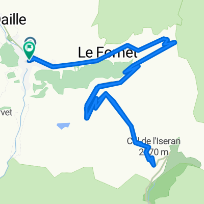
Overview
About this route
Desde Lanslevillard se sube el col de Mont Cenis. Se rodea al lago ya sin asfalto hasta el desvío al col de Petit Col de Mont Cenis por las praderas de la cumbre.
En la bajada no hay más que un sendero donde toca arrastra las bicis. Se llega a una pista que baja enseguida al valle de la Maurenne. Por la carretera principal se alcanza el punto de partida.
- -:--
- Duration
- 47 km
- Distance
- 1,108 m
- Ascent
- 1,108 m
- Descent
- ---
- Avg. speed
- ---
- Max. altitude
Continue with Bikemap
Use, edit, or download this cycling route
You would like to ride Cols de Mont Cenis y Petit Mont Cenis or customize it for your own trip? Here is what you can do with this Bikemap route:
Free features
- Save this route as favorite or in collections
- Copy & plan your own version of this route
- Sync your route with Garmin or Wahoo
Premium features
Free trial for 3 days, or one-time payment. More about Bikemap Premium.
- Navigate this route on iOS & Android
- Export a GPX / KML file of this route
- Create your custom printout (try it for free)
- Download this route for offline navigation
Discover more Premium features.
Get Bikemap PremiumFrom our community
Other popular routes starting in Val d'Isère
 Col de l'ISeran
- Distance
- 40.9 km
- Ascent
- 1,213 m
- Descent
- 1,209 m
- Location
- Val d'Isère, Auvergne-Rhône-Alpes, France
 Val D'Isere - Col d'Iseran - Col du Mont Cenis
- Distance
- 65.1 km
- Ascent
- 1,563 m
- Descent
- 1,917 m
- Location
- Val d'Isère, Auvergne-Rhône-Alpes, France
 AlpenTour2018_E4-8
- Distance
- 120.2 km
- Ascent
- 2,610 m
- Descent
- 3,066 m
- Location
- Val d'Isère, Auvergne-Rhône-Alpes, France
 Cols de Mont Cenis y Petit Mont Cenis
- Distance
- 47 km
- Ascent
- 1,108 m
- Descent
- 1,108 m
- Location
- Val d'Isère, Auvergne-Rhône-Alpes, France
 Alpencross 2007/4 - Bessans bis Frais
- Distance
- 74.6 km
- Ascent
- 2,291 m
- Descent
- 2,502 m
- Location
- Val d'Isère, Auvergne-Rhône-Alpes, France
 3-Tag_ValD-isere-Valloire
- Distance
- 114.3 km
- Ascent
- 1,895 m
- Descent
- 2,305 m
- Location
- Val d'Isère, Auvergne-Rhône-Alpes, France
 2017-08-12 / Col de l'Iseran, toit du sėjour !
- Distance
- 65.9 km
- Ascent
- 1,460 m
- Descent
- 1,477 m
- Location
- Val d'Isère, Auvergne-Rhône-Alpes, France
 021 - 2014
- Distance
- 68.9 km
- Ascent
- 1,825 m
- Descent
- 2,036 m
- Location
- Val d'Isère, Auvergne-Rhône-Alpes, France
Open it in the app