

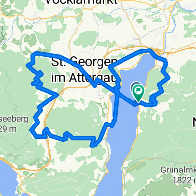
Legends 2017 Tag 3 - Variante 1
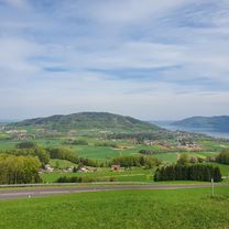
A cycling route starting in Attersee, Upper Austria, Austria.
Overview
About this route
Hotel - Weißenbach - Bad Ischl - St. Gilgen = 52 km (Pause)
Fuschl - Thalgau - Plornberg - Weißenbach - Hotel = 53 km
Total = 105 km / HM 900 m
- -:--
- Duration
- 105.2 km
- Distance
- 709 m
- Ascent
- 712 m
- Descent
- ---
- Avg. speed
- ---
- Max. altitude

Route quality
Waytypes & surfaces along the route
Waytypes
Road
21 km
(20 %)
Path
15.8 km
(15 %)
Surfaces
Paved
84.2 km
(80 %)
Unpaved
1.1 km
(1 %)
Asphalt
84.2 km
(80 %)
Gravel
1.1 km
(1 %)
Undefined
20 km
(19 %)
Route highlights
Points of interest along the route
Drinking water after 52.3 km
Pause
Continue with Bikemap
Use, edit, or download this cycling route
You would like to ride Legends 2017 Tag 3 - Variante 1 or customize it for your own trip? Here is what you can do with this Bikemap route:
Free features
- Save this route as favorite or in collections
- Copy & plan your own version of this route
- Split it into stages to create a multi-day tour
- Sync your route with Garmin or Wahoo
Premium features
Free trial for 3 days, or one-time payment. More about Bikemap Premium.
- Navigate this route on iOS & Android
- Export a GPX / KML file of this route
- Create your custom printout (try it for free)
- Download this route for offline navigation
Discover more Premium features.
Get Bikemap PremiumFrom our community
Other popular routes starting in Attersee
 Runde um den Attersee
- Distance
- 58.6 km
- Ascent
- 481 m
- Descent
- 467 m
- Location
- Attersee, Upper Austria, Austria
 Buchberg-Kronberg Runde
- Distance
- 21.2 km
- Ascent
- 259 m
- Descent
- 405 m
- Location
- Attersee, Upper Austria, Austria
 2025_06_Weyregg-Reindlmühle
- Distance
- 32.4 km
- Ascent
- 1,071 m
- Descent
- 1,017 m
- Location
- Attersee, Upper Austria, Austria
 Attersee és Mondsee
- Distance
- 81.3 km
- Ascent
- 411 m
- Descent
- 411 m
- Location
- Attersee, Upper Austria, Austria
 Rund um den Attersee und Buchberg. 🚴♂️🚴
- Distance
- 49.8 km
- Ascent
- 921 m
- Descent
- 916 m
- Location
- Attersee, Upper Austria, Austria
Garmin
Kabong mit Schiff- Distance
- 74.8 km
- Ascent
- 1,738 m
- Descent
- 1,778 m
- Location
- Attersee, Upper Austria, Austria
 Legends 2017 Tag 1 - Variante 1
- Distance
- 78.9 km
- Ascent
- 361 m
- Descent
- 371 m
- Location
- Attersee, Upper Austria, Austria
 Attersee - Mondsee -Attersee
- Distance
- 41.2 km
- Ascent
- 354 m
- Descent
- 355 m
- Location
- Attersee, Upper Austria, Austria
Open it in the app