

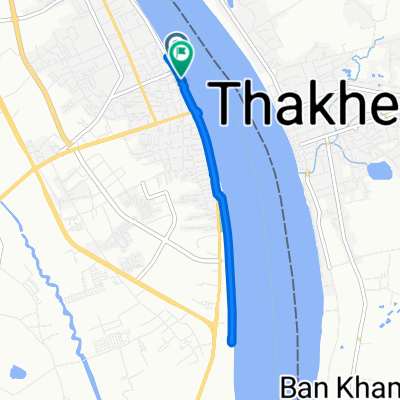
J037 – Samedi 11 février 2017 Nakhon Phanom (Thaïlande) – Thakhek (Laos)
A cycling route starting in Nakhon Phanom, Nakhon Phanom, Thailand.
Overview
About this route
J037 – Saturday, February 11, 2017
Nakhon Phanom (Thailand) – Thakhek (Laos)
40.56 Km – Average speed: 12.66 Km/h
Ascent: 108 m - Descent: 108 m.
Max incline uphill: 5 % - Max incline downhill: 5 %
Start altitude: 139 m – Arrival altitude: 139 m – Max altitude: 174 m.
The route includes crossing Friendship Bridge 3 by bus (about 2 km) but does not include the route through Thakhek (bank, restaurant, etc.). The mileage on the trip meter does not include crossing Friendship Bridge 3 but does account for the distance traveled in Thakhek.
- -:--
- Duration
- 35.9 km
- Distance
- 117 m
- Ascent
- 115 m
- Descent
- ---
- Avg. speed
- ---
- Max. altitude
Continue with Bikemap
Use, edit, or download this cycling route
You would like to ride J037 – Samedi 11 février 2017 Nakhon Phanom (Thaïlande) – Thakhek (Laos) or customize it for your own trip? Here is what you can do with this Bikemap route:
Free features
- Save this route as favorite or in collections
- Copy & plan your own version of this route
- Sync your route with Garmin or Wahoo
Premium features
Free trial for 3 days, or one-time payment. More about Bikemap Premium.
- Navigate this route on iOS & Android
- Export a GPX / KML file of this route
- Create your custom printout (try it for free)
- Download this route for offline navigation
Discover more Premium features.
Get Bikemap PremiumFrom our community
Other popular routes starting in Nakhon Phanom
 Loop Thakhek
- Distance
- 350 km
- Ascent
- 1,131 m
- Descent
- 1,101 m
- Location
- Nakhon Phanom, Nakhon Phanom, Thailand
 ถนนศรีเทพ, อ.เมืองนครพนม to ถนนศรีเทพ, อ.เมืองนครพนม
- Distance
- 8.7 km
- Ascent
- 9 m
- Descent
- 19 m
- Location
- Nakhon Phanom, Nakhon Phanom, Thailand
 นครพนม
- Distance
- 6.2 km
- Ascent
- 18 m
- Descent
- 17 m
- Location
- Nakhon Phanom, Nakhon Phanom, Thailand
 ปั่นเรื่อยๆเปื่อยๆ
- Distance
- 19.9 km
- Ascent
- 24 m
- Descent
- 24 m
- Location
- Nakhon Phanom, Nakhon Phanom, Thailand
 ชายโขง8ชนเผ่านคร
- Distance
- 12.4 km
- Ascent
- 52 m
- Descent
- 37 m
- Location
- Nakhon Phanom, Nakhon Phanom, Thailand
 J037 – Samedi 11 février 2017 Nakhon Phanom (Thaïlande) – Thakhek (Laos)
- Distance
- 35.9 km
- Ascent
- 117 m
- Descent
- 115 m
- Location
- Nakhon Phanom, Nakhon Phanom, Thailand
 Nakornpanom - Sapa
- Distance
- 1,433.4 km
- Ascent
- 6,810 m
- Descent
- 6,877 m
- Location
- Nakhon Phanom, Nakhon Phanom, Thailand
 อำเภอเมืองนครพนม, ตำบล ในเมือง to อำเภอเมืองนครพนม, ตำบล ในเมือง
- Distance
- 9.3 km
- Ascent
- 77 m
- Descent
- 77 m
- Location
- Nakhon Phanom, Nakhon Phanom, Thailand
Open it in the app