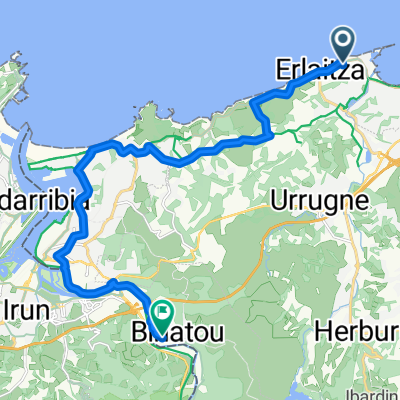
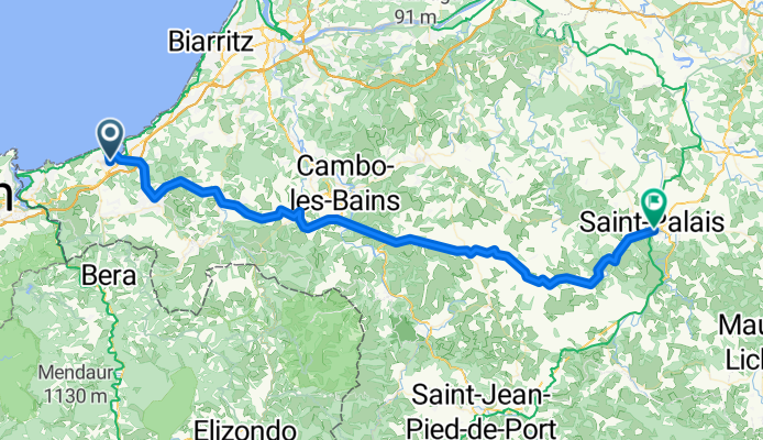
Pyrenäen-Bergschnecken
#1 AAA Bergschnecke-Pyrenäen
A cycling route starting in Ciboure, Aquitaine-Limousin-Poitou-Charentes, France.
Overview
About this route
- -:--
- Duration
- 70.8 km
- Distance
- 541 m
- Ascent
- 548 m
- Descent
- ---
- Avg. speed
- ---
- Max. altitude
Part of
Pyrenäen-Bergschnecken
1 stage
Route quality
Waytypes & surfaces along the route
Waytypes
Busy road
37.4 km
(53 %)
Road
21.3 km
(30 %)
Surfaces
Paved
30.3 km
(43 %)
Asphalt
30.3 km
(43 %)
Undefined
40.5 km
(57 %)
Continue with Bikemap
Use, edit, or download this cycling route
You would like to ride #1 AAA Bergschnecke-Pyrenäen or customize it for your own trip? Here is what you can do with this Bikemap route:
Free features
- Save this route as favorite or in collections
- Copy & plan your own version of this route
- Sync your route with Garmin or Wahoo
Premium features
Free trial for 3 days, or one-time payment. More about Bikemap Premium.
- Navigate this route on iOS & Android
- Export a GPX / KML file of this route
- Create your custom printout (try it for free)
- Download this route for offline navigation
Discover more Premium features.
Get Bikemap PremiumFrom our community
Other popular routes starting in Ciboure
- #1 AAA Bergschnecke-Pyrenäen
- Distance
- 70.8 km
- Ascent
- 541 m
- Descent
- 548 m
- Location
- Ciboure, Aquitaine-Limousin-Poitou-Charentes, France
- De Boulevard Pierre Benoit, Ciboure Ă 35 Rue de Madrid, Biarritz
- Distance
- 19.7 km
- Ascent
- 4 m
- Descent
- 7 m
- Location
- Ciboure, Aquitaine-Limousin-Poitou-Charentes, France
- Sain Jean de Luz - Eibar Arrate (spa)
- Distance
- 175.8 km
- Ascent
- 3,852 m
- Descent
- 3,332 m
- Location
- Ciboure, Aquitaine-Limousin-Poitou-Charentes, France
- 31/05
- Distance
- 43 km
- Ascent
- 322 m
- Descent
- 323 m
- Location
- Ciboure, Aquitaine-Limousin-Poitou-Charentes, France
- Sin Jean de Luz - Sare (dĂa 3)
- Distance
- 61.8 km
- Ascent
- 401 m
- Descent
- 364 m
- Location
- Ciboure, Aquitaine-Limousin-Poitou-Charentes, France
- Urrugne - Urrugne
- Distance
- 103 km
- Ascent
- 2,931 m
- Descent
- 2,926 m
- Location
- Ciboure, Aquitaine-Limousin-Poitou-Charentes, France
- Saint Jean de Luz - Eibar Anrate (Spa.)
- Distance
- 172.6 km
- Ascent
- 3,878 m
- Descent
- 3,359 m
- Location
- Ciboure, Aquitaine-Limousin-Poitou-Charentes, France
- Pays-Basque
- Distance
- 91.9 km
- Ascent
- 779 m
- Descent
- 781 m
- Location
- Ciboure, Aquitaine-Limousin-Poitou-Charentes, France
Open it in the app