

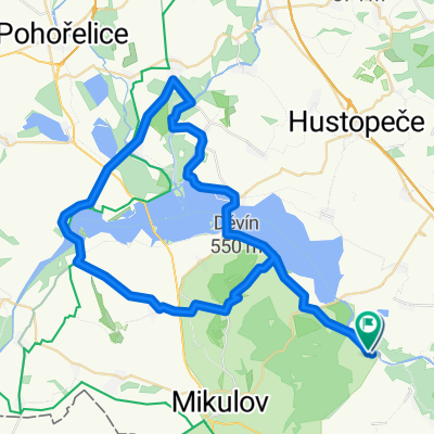
Lednice Valtice Dyje 55 km
A cycling route starting in Zaječí, South Moravian, Czechia.
Overview
About this route
- -:--
- Duration
- 55.2 km
- Distance
- 156 m
- Ascent
- 155 m
- Descent
- ---
- Avg. speed
- ---
- Max. altitude

Route quality
Waytypes & surfaces along the route
Waytypes
Track
34.3 km
(62 %)
Quiet road
5.5 km
(10 %)
Surfaces
Paved
18.2 km
(33 %)
Unpaved
27.1 km
(49 %)
Asphalt
16 km
(29 %)
Gravel
12.2 km
(22 %)
Continue with Bikemap
Use, edit, or download this cycling route
You would like to ride Lednice Valtice Dyje 55 km or customize it for your own trip? Here is what you can do with this Bikemap route:
Free features
- Save this route as favorite or in collections
- Copy & plan your own version of this route
- Sync your route with Garmin or Wahoo
Premium features
Free trial for 3 days, or one-time payment. More about Bikemap Premium.
- Navigate this route on iOS & Android
- Export a GPX / KML file of this route
- Create your custom printout (try it for free)
- Download this route for offline navigation
Discover more Premium features.
Get Bikemap PremiumFrom our community
Other popular routes starting in Zaječí
 Firemny sklipek Pritluky
- Distance
- 29.3 km
- Ascent
- 168 m
- Descent
- 167 m
- Location
- Zaječí, South Moravian, Czechia
 Přítluky - mandlový sad 2017
- Distance
- 41.9 km
- Ascent
- 483 m
- Descent
- 483 m
- Location
- Zaječí, South Moravian, Czechia
 Vinařská do Zámecké náměstí
- Distance
- 36.4 km
- Ascent
- 162 m
- Descent
- 264 m
- Location
- Zaječí, South Moravian, Czechia
 Bulhary- Iváň -Pasohlávky - Bulhary
- Distance
- 58.3 km
- Ascent
- 267 m
- Descent
- 264 m
- Location
- Zaječí, South Moravian, Czechia
 Putování po Modrých horách
- Distance
- 48.7 km
- Ascent
- 510 m
- Descent
- 510 m
- Location
- Zaječí, South Moravian, Czechia
 Palava 04
- Distance
- 54.7 km
- Ascent
- 317 m
- Descent
- 314 m
- Location
- Zaječí, South Moravian, Czechia
 Zaječí - Nové Mlýny - Zaječí
- Distance
- 56.3 km
- Ascent
- 240 m
- Descent
- 240 m
- Location
- Zaječí, South Moravian, Czechia
 Lednice Valtice Dyje 55 km
- Distance
- 55.2 km
- Ascent
- 156 m
- Descent
- 155 m
- Location
- Zaječí, South Moravian, Czechia
Open it in the app