

Atlantai út
A cycling route starting in Brookhaven, Georgia, United States.
Overview
About this route
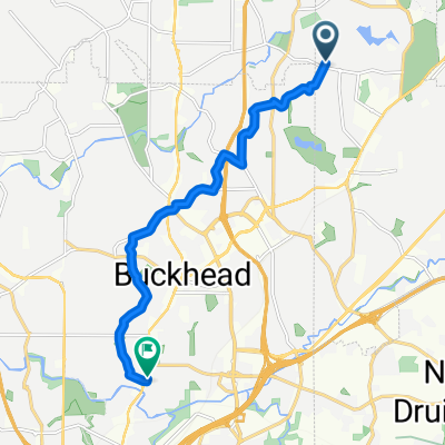
Description of the Atlanta route. Created on Bikemap.
- -:--
- Duration
- 22.8 km
- Distance
- 161 m
- Ascent
- 161 m
- Descent
- ---
- Avg. speed
- ---
- Max. altitude
Continue with Bikemap
Use, edit, or download this cycling route
You would like to ride Atlantai út or customize it for your own trip? Here is what you can do with this Bikemap route:
Free features
- Save this route as favorite or in collections
- Copy & plan your own version of this route
- Sync your route with Garmin or Wahoo
Premium features
Free trial for 3 days, or one-time payment. More about Bikemap Premium.
- Navigate this route on iOS & Android
- Export a GPX / KML file of this route
- Create your custom printout (try it for free)
- Download this route for offline navigation
Discover more Premium features.
Get Bikemap PremiumFrom our community
Other popular routes starting in Brookhaven
 north loop
- Distance
- 16.3 km
- Ascent
- 254 m
- Descent
- 256 m
- Location
- Brookhaven, Georgia, United States
 Candler Park to CDC - Corporate Square
- Distance
- 11.3 km
- Ascent
- 159 m
- Descent
- 104 m
- Location
- Brookhaven, Georgia, United States
 Silver Lake / Brittany / Capital City
- Distance
- 17 km
- Ascent
- 228 m
- Descent
- 225 m
- Location
- Brookhaven, Georgia, United States
 Atlantai út
- Distance
- 22.8 km
- Ascent
- 161 m
- Descent
- 161 m
- Location
- Brookhaven, Georgia, United States
 Whitehall Tavern 2
- Distance
- 11.3 km
- Ascent
- 116 m
- Descent
- 172 m
- Location
- Brookhaven, Georgia, United States
 Fadi's Brookhaven Lake Loop
- Distance
- 14.7 km
- Ascent
- 213 m
- Descent
- 212 m
- Location
- Brookhaven, Georgia, United States
 Easy ride in Chamblee
- Distance
- 7.1 km
- Ascent
- 92 m
- Descent
- 94 m
- Location
- Brookhaven, Georgia, United States
 Leizure bike ride
- Distance
- 6.6 km
- Ascent
- 83 m
- Descent
- 84 m
- Location
- Brookhaven, Georgia, United States
Open it in the app