Zrušenky
A cycling route starting in Bučovice, South Moravian, Czechia.
Overview
About this route
Zrušenky
- -:--
- Duration
- 416.1 km
- Distance
- 1,296 m
- Ascent
- 1,133 m
- Descent
- ---
- Avg. speed
- ---
- Avg. speed
Route quality
Waytypes & surfaces along the route
Waytypes
Road
118.1 km
(28 %)
Busy road
115.2 km
(28 %)
Surfaces
Paved
214.2 km
(51 %)
Unpaved
9.7 km
(2 %)
Asphalt
209.1 km
(50 %)
Unpaved (undefined)
5.3 km
(1 %)
Route highlights
Points of interest along the route
Accommodation after 38.2 km
V zastávce
Drinking water after 53.2 km
Nový Svět
Drinking water after 72.6 km
TILAK
Drinking water after 98.2 km
Na koupališti
Drinking water after 120.9 km
Drinking water after 150.4 km
Pivovar
Accommodation after 160.3 km
Přístřešek
Drinking water after 190.6 km
Šaman
Drinking water after 207.6 km
Nano
Point of interest after 236.7 km
Vlakem do Čermné
Accommodation after 258.7 km
RZ Zálesí
Drinking water after 274.1 km
Bistro
Drinking water after 309.5 km
G-centrum
Accommodation after 349.8 km
Hostinec u Peterků
Continue with Bikemap
Use, edit, or download this cycling route
You would like to ride Zrušenky or customize it for your own trip? Here is what you can do with this Bikemap route:
Free features
- Save this route as favorite or in collections
- Copy & plan your own version of this route
- Sync your route with Garmin or Wahoo
Premium features
Free trial for 3 days, or one-time payment. More about Bikemap Premium.
- Navigate this route on iOS & Android
- Export a GPX / KML file of this route
- Create your custom printout (try it for free)
- Download this route for offline navigation
Discover more Premium features.
Get Bikemap PremiumFrom our community
Other popular routes starting in Bučovice
- Bucovice - Kloboucky - Jitrenka - U slepice - Cerveny kriz - U zlateho jelena - Jalovy Dvur - Rasovice - Krizanovice - Marefy
- Distance
- 33.4 km
- Ascent
- 313 m
- Descent
- 316 m
- Location
- Bučovice, South Moravian, Czechia
- buc-sub / zdansky les
- Distance
- 39.9 km
- Ascent
- 382 m
- Descent
- 382 m
- Location
- Bučovice, South Moravian, Czechia
- Marefy-Korycany-Kostelec 70K
- Distance
- 69.8 km
- Ascent
- 542 m
- Descent
- 543 m
- Location
- Bučovice, South Moravian, Czechia
- Bučovice - Šošůvka - Sloup - Bučovice
- Distance
- 100 km
- Ascent
- 839 m
- Descent
- 845 m
- Location
- Bučovice, South Moravian, Czechia
- Zrušenky
- Distance
- 416.1 km
- Ascent
- 1,296 m
- Descent
- 1,133 m
- Location
- Bučovice, South Moravian, Czechia
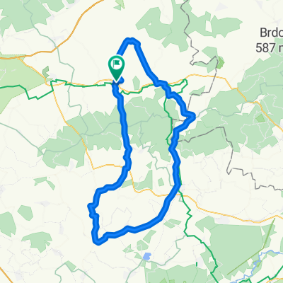
- Ruta Sudeste Bučovice
- Distance
- 81 km
- Ascent
- 887 m
- Descent
- 887 m
- Location
- Bučovice, South Moravian, Czechia
- 45k Marefy
- Distance
- 44.9 km
- Ascent
- 277 m
- Descent
- 273 m
- Location
- Bučovice, South Moravian, Czechia
- bčovice - drahany - bučovice
- Distance
- 96.8 km
- Ascent
- 912 m
- Descent
- 911 m
- Location
- Bučovice, South Moravian, Czechia
Open it in the app