

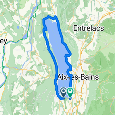
Mont du Chat via Col du Chat
A cycling route starting in Le Bourget-du-Lac, Auvergne-Rhône-Alpes, France.
Overview
About this route
Great loop including the super steep east side of Mont du Chat - will be in 2017 Tour de France. Note, west side currently closed with snow (I hiked)
- -:--
- Duration
- 68.4 km
- Distance
- 1,961 m
- Ascent
- 1,960 m
- Descent
- ---
- Avg. speed
- ---
- Max. altitude

Route photos


Route highlights
Points of interest along the route
Point of interest after 8.4 km
Col du Chat
Point of interest after 20.1 km
Ontex descent
Point of interest after 29.1 km
Cote de Jongieux
Point of interest after 55.9 km
Relais du Mont du Chat
Continue with Bikemap
Use, edit, or download this cycling route
You would like to ride Mont du Chat via Col du Chat or customize it for your own trip? Here is what you can do with this Bikemap route:
Free features
- Save this route as favorite or in collections
- Copy & plan your own version of this route
- Sync your route with Garmin or Wahoo
Premium features
Free trial for 3 days, or one-time payment. More about Bikemap Premium.
- Navigate this route on iOS & Android
- Export a GPX / KML file of this route
- Create your custom printout (try it for free)
- Download this route for offline navigation
Discover more Premium features.
Get Bikemap PremiumFrom our community
Other popular routes starting in Le Bourget-du-Lac
 INES- Entre Deux Guiers via col de l'Epine
- Distance
- 53.3 km
- Ascent
- 1,155 m
- Descent
- 1,001 m
- Location
- Le Bourget-du-Lac, Auvergne-Rhône-Alpes, France
 Chambéry-Bienne
- Distance
- 474.9 km
- Ascent
- 4,392 m
- Descent
- 4,188 m
- Location
- Le Bourget-du-Lac, Auvergne-Rhône-Alpes, France
 Bourget
- Distance
- 49.5 km
- Ascent
- 670 m
- Descent
- 672 m
- Location
- Le Bourget-du-Lac, Auvergne-Rhône-Alpes, France
 D 1201 A, Le Bourget-du-Lac à Montée de Pouli, Le Bourget-du-Lac
- Distance
- 4.7 km
- Ascent
- 96 m
- Descent
- 114 m
- Location
- Le Bourget-du-Lac, Auvergne-Rhône-Alpes, France
 INES- Entre Deux Guiers via l'antenne du chat
- Distance
- 59 km
- Ascent
- 1,627 m
- Descent
- 1,473 m
- Location
- Le Bourget-du-Lac, Auvergne-Rhône-Alpes, France
 Mont du Chat via Col du Chat
- Distance
- 68.4 km
- Ascent
- 1,961 m
- Descent
- 1,960 m
- Location
- Le Bourget-du-Lac, Auvergne-Rhône-Alpes, France
 Mont (Relais) du Chat and Col de l'Epine
- Distance
- 54 km
- Ascent
- 1,794 m
- Descent
- 1,794 m
- Location
- Le Bourget-du-Lac, Auvergne-Rhône-Alpes, France
 Strecke H: Lac de Bourget nach Lac Leman
- Distance
- 119.4 km
- Ascent
- 1,396 m
- Descent
- 1,225 m
- Location
- Le Bourget-du-Lac, Auvergne-Rhône-Alpes, France
Open it in the app