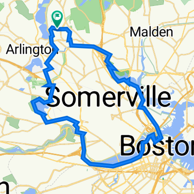
Strawberry Hill Curve street Loop CLONED FROM ROUTE 183722
A cycling route starting in Arlington, Massachusetts, United States of America.
Overview
About this route
This is the typical route for me "fast group" that guides with Bobby Mac as part of the Quad Cycles training rides.
Rural/suburban
scenic
- -:--
- Duration
- 57.5 km
- Distance
- 315 m
- Ascent
- 305 m
- Descent
- ---
- Avg. speed
- 90 m
- Avg. speed
Route quality
Waytypes & surfaces along the route
Waytypes
Cycleway
20.4 km
(36 %)
Quiet road
13.5 km
(23 %)
Surfaces
Paved
49.1 km
(85 %)
Unpaved
0.2 km
(<1 %)
Asphalt
48.3 km
(84 %)
Paved (undefined)
0.7 km
(1 %)
Continue with Bikemap
Use, edit, or download this cycling route
You would like to ride Strawberry Hill Curve street Loop CLONED FROM ROUTE 183722 or customize it for your own trip? Here is what you can do with this Bikemap route:
Free features
- Save this route as favorite or in collections
- Copy & plan your own version of this route
- Sync your route with Garmin or Wahoo
Premium features
Free trial for 3 days, or one-time payment. More about Bikemap Premium.
- Navigate this route on iOS & Android
- Export a GPX / KML file of this route
- Create your custom printout (try it for free)
- Download this route for offline navigation
Discover more Premium features.
Get Bikemap PremiumFrom our community
Other popular routes starting in Arlington
- Walden Pond - Walden Pond
- Distance
- 46.6 km
- Ascent
- 459 m
- Descent
- 458 m
- Location
- Arlington, Massachusetts, United States of America
- Walden Pond + deCordova
- Distance
- 44.4 km
- Ascent
- 228 m
- Descent
- 228 m
- Location
- Arlington, Massachusetts, United States of America
- Minuteman Loop
- Distance
- 45.1 km
- Ascent
- 344 m
- Descent
- 346 m
- Location
- Arlington, Massachusetts, United States of America
- Cambridge Watertown Loop
- Distance
- 43.8 km
- Ascent
- 244 m
- Descent
- 244 m
- Location
- Arlington, Massachusetts, United States of America
- Walden Pond Loop From Hunnewell Hill
- Distance
- 63.9 km
- Ascent
- 506 m
- Descent
- 482 m
- Location
- Arlington, Massachusetts, United States of America
- Arlington Lexington Burlington Woburn Winchester Loop
- Distance
- 25.3 km
- Ascent
- 108 m
- Descent
- 108 m
- Location
- Arlington, Massachusetts, United States of America
- Cambridge to Gore Place
- Distance
- 10.5 km
- Ascent
- 68 m
- Descent
- 57 m
- Location
- Arlington, Massachusetts, United States of America
- Strawberry Hill Curve street Loop CLONED FROM ROUTE 183722
- Distance
- 57.5 km
- Ascent
- 315 m
- Descent
- 305 m
- Location
- Arlington, Massachusetts, United States of America