
Alpencross 2te
A cycling route starting in Mayrhofen, Tyrol, Austria.
Overview
About this route
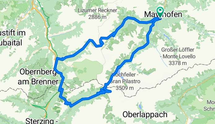
Von Mayerhofen übers Tuxerjoch bis zur Enzianhütte.Am nächsten Tag übers Satteljoch und Pfitscherjoch nach Mayerhofen zurück
- -:--
- Duration
- 117 km
- Distance
- 3,629 m
- Ascent
- 3,630 m
- Descent
- ---
- Avg. speed
- ---
- Max. altitude

Route highlights
Points of interest along the route
Point of interest after 58.9 km
Enzianhütte
Continue with Bikemap
Use, edit, or download this cycling route
You would like to ride Alpencross 2te or customize it for your own trip? Here is what you can do with this Bikemap route:
Free features
- Save this route as favorite or in collections
- Copy & plan your own version of this route
- Split it into stages to create a multi-day tour
- Sync your route with Garmin or Wahoo
Premium features
Free trial for 3 days, or one-time payment. More about Bikemap Premium.
- Navigate this route on iOS & Android
- Export a GPX / KML file of this route
- Create your custom printout (try it for free)
- Download this route for offline navigation
Discover more Premium features.
Get Bikemap PremiumFrom our community
Other popular routes starting in Mayrhofen
 Alpencross 2te
- Distance
- 117 km
- Ascent
- 3,629 m
- Descent
- 3,630 m
- Location
- Mayrhofen, Tyrol, Austria
 A Mayrhofen 45 rovina
- Distance
- 43.9 km
- Ascent
- 176 m
- Descent
- 175 m
- Location
- Mayrhofen, Tyrol, Austria
 Zillertaler Berg Klassiker
- Distance
- 120 km
- Ascent
- 2,140 m
- Descent
- 2,101 m
- Location
- Mayrhofen, Tyrol, Austria
 Stilluptal
- Distance
- 36 km
- Ascent
- 831 m
- Descent
- 829 m
- Location
- Mayrhofen, Tyrol, Austria
 Mayrh. Pfundsalm Fügen
- Distance
- 58.6 km
- Ascent
- 1,657 m
- Descent
- 1,657 m
- Location
- Mayrhofen, Tyrol, Austria
 Rund um Juns
- Distance
- 11.3 km
- Ascent
- 578 m
- Descent
- 576 m
- Location
- Mayrhofen, Tyrol, Austria
 2024_MTB_Z_Rossalm
- Distance
- 61.8 km
- Ascent
- 2,092 m
- Descent
- 2,090 m
- Location
- Mayrhofen, Tyrol, Austria
 Ahornstraße 855, Mayrhofen nach Stillup 967, Mayrhofen
- Distance
- 15.4 km
- Ascent
- 881 m
- Descent
- 94 m
- Location
- Mayrhofen, Tyrol, Austria
Open it in the app