
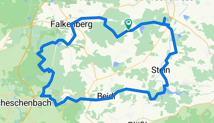
41 km waldnaabtal 440hm
A cycling route starting in Tirschenreuth, Bavaria, Germany.
Overview
About this route
- -:--
- Duration
- 41.5 km
- Distance
- 343 m
- Ascent
- 347 m
- Descent
- ---
- Avg. speed
- ---
- Max. altitude

Route quality
Waytypes & surfaces along the route
Waytypes
Track
27 km
(65 %)
Quiet road
10.9 km
(26 %)
Surfaces
Paved
18.6 km
(45 %)
Unpaved
22.8 km
(55 %)
Asphalt
18.6 km
(45 %)
Gravel
15.5 km
(37 %)
Continue with Bikemap
Use, edit, or download this cycling route
You would like to ride 41 km waldnaabtal 440hm or customize it for your own trip? Here is what you can do with this Bikemap route:
Free features
- Save this route as favorite or in collections
- Copy & plan your own version of this route
- Sync your route with Garmin or Wahoo
Premium features
Free trial for 3 days, or one-time payment. More about Bikemap Premium.
- Navigate this route on iOS & Android
- Export a GPX / KML file of this route
- Create your custom printout (try it for free)
- Download this route for offline navigation
Discover more Premium features.
Get Bikemap PremiumFrom our community
Other popular routes starting in Tirschenreuth
 BR Radltour 2013 - Etappe 6 - Pegnitz - Tirschenreutsch - Ziel - Quartier
- Distance
- 1.6 km
- Ascent
- 16 m
- Descent
- 25 m
- Location
- Tirschenreuth, Bavaria, Germany
 TIR-Falkenberg-Teichpfanne-TIR
- Distance
- 39.3 km
- Ascent
- 187 m
- Descent
- 189 m
- Location
- Tirschenreuth, Bavaria, Germany
 Egergrabentour
- Distance
- 59.7 km
- Ascent
- 6,461 m
- Descent
- 6,461 m
- Location
- Tirschenreuth, Bavaria, Germany
 LL-03-1 Tirschenreuth - Loket
- Distance
- 22.9 km
- Ascent
- 400 m
- Descent
- 391 m
- Location
- Tirschenreuth, Bavaria, Germany
 Tirschenreuth - Waldhäusl - Alter Herrgott - Dylen
- Distance
- 44.9 km
- Ascent
- 662 m
- Descent
- 657 m
- Location
- Tirschenreuth, Bavaria, Germany
 Ins Egerland Teil 2
- Distance
- 54.6 km
- Ascent
- 439 m
- Descent
- 438 m
- Location
- Tirschenreuth, Bavaria, Germany
 41 km waldnaabtal 440hm
- Distance
- 41.5 km
- Ascent
- 343 m
- Descent
- 347 m
- Location
- Tirschenreuth, Bavaria, Germany
 tour 170505 vizinalbahn - havran cz
- Distance
- 61.4 km
- Ascent
- 655 m
- Descent
- 654 m
- Location
- Tirschenreuth, Bavaria, Germany
Open it in the app