

Privat Etappe 2
A cycling route starting in Treptow, State of Berlin, Germany.
Overview
About this route
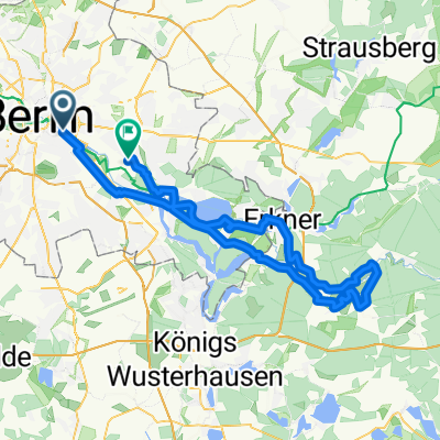
Oberbaumbrücke so weit wir kommen Richtung Kiessee
- -:--
- Duration
- 37.2 km
- Distance
- 75 m
- Ascent
- 69 m
- Descent
- ---
- Avg. speed
- ---
- Max. altitude

Route photos


Continue with Bikemap
Use, edit, or download this cycling route
You would like to ride Privat Etappe 2 or customize it for your own trip? Here is what you can do with this Bikemap route:
Free features
- Save this route as favorite or in collections
- Copy & plan your own version of this route
- Sync your route with Garmin or Wahoo
Premium features
Free trial for 3 days, or one-time payment. More about Bikemap Premium.
- Navigate this route on iOS & Android
- Export a GPX / KML file of this route
- Create your custom printout (try it for free)
- Download this route for offline navigation
Discover more Premium features.
Get Bikemap PremiumFrom our community
Other popular routes starting in Treptow
 Rund um Schönefeld
- Distance
- 48.5 km
- Ascent
- 73 m
- Descent
- 83 m
- Location
- Treptow, State of Berlin, Germany
 East Side Gallery – Rathaus Spandau
- Distance
- 25.9 km
- Ascent
- 92 m
- Descent
- 88 m
- Location
- Treptow, State of Berlin, Germany
 Privat Etappe 2
- Distance
- 37.2 km
- Ascent
- 75 m
- Descent
- 69 m
- Location
- Treptow, State of Berlin, Germany
 Kreuzberg - Grünau (fast) ohne Autos
- Distance
- 17.4 km
- Ascent
- 8 m
- Descent
- 11 m
- Location
- Treptow, State of Berlin, Germany
 Feierabendrunde: Berlin-KW-Berlin
- Distance
- 43.3 km
- Ascent
- 47 m
- Descent
- 47 m
- Location
- Treptow, State of Berlin, Germany
 nah am wasser gebaut
- Distance
- 15 km
- Ascent
- 19 m
- Descent
- 32 m
- Location
- Treptow, State of Berlin, Germany
 Spreewiesentour
- Distance
- 86.3 km
- Ascent
- 228 m
- Descent
- 222 m
- Location
- Treptow, State of Berlin, Germany
 Berlin-Darmstadt Rennrad
- Distance
- 558.2 km
- Ascent
- 1,417 m
- Descent
- 1,315 m
- Location
- Treptow, State of Berlin, Germany
Open it in the app