

Day10-1-2 Schwarzsee-Furi trail
A cycling route starting in Zermatt, Valais, Switzerland.
Overview
About this route
- -:--
- Duration
- 6.8 km
- Distance
- 17 m
- Ascent
- 983 m
- Descent
- ---
- Avg. speed
- ---
- Max. altitude

Route highlights
Points of interest along the route
Accommodation after 5 km
Continue with Bikemap
Use, edit, or download this cycling route
You would like to ride Day10-1-2 Schwarzsee-Furi trail or customize it for your own trip? Here is what you can do with this Bikemap route:
Free features
- Save this route as favorite or in collections
- Copy & plan your own version of this route
- Sync your route with Garmin or Wahoo
Premium features
Free trial for 3 days, or one-time payment. More about Bikemap Premium.
- Navigate this route on iOS & Android
- Export a GPX / KML file of this route
- Create your custom printout (try it for free)
- Download this route for offline navigation
Discover more Premium features.
Get Bikemap PremiumFrom our community
Other popular routes starting in Zermatt
 Sunnegga-Zermatt
- Distance
- 5.4 km
- Ascent
- 37 m
- Descent
- 683 m
- Location
- Zermatt, Valais, Switzerland
 zermatt
- Distance
- 10.1 km
- Ascent
- 987 m
- Descent
- 0 m
- Location
- Zermatt, Valais, Switzerland
 Zermatt
- Distance
- 21.4 km
- Ascent
- 916 m
- Descent
- 914 m
- Location
- Zermatt, Valais, Switzerland
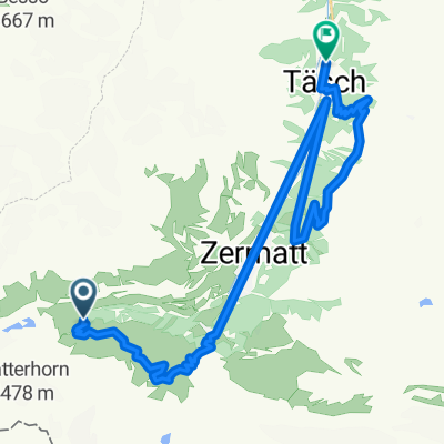
 täschalp
- Distance
- 7 km
- Ascent
- 725 m
- Descent
- 16 m
- Location
- Zermatt, Valais, Switzerland
 Day11-1 Schwarzsee -Edelweis- Zmutt Trail
- Distance
- 10.4 km
- Ascent
- 53 m
- Descent
- 1,003 m
- Location
- Zermatt, Valais, Switzerland
 Gornegat - Zermatt 1 laskumine
- Distance
- 16.8 km
- Ascent
- 40 m
- Descent
- 1,520 m
- Location
- Zermatt, Valais, Switzerland
 Day11-2 Rothorn left
- Distance
- 7.9 km
- Ascent
- 0 m
- Descent
- 1,388 m
- Location
- Zermatt, Valais, Switzerland
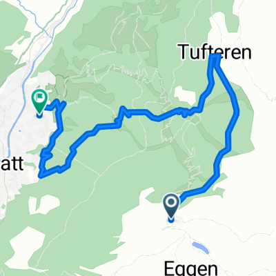
 Tasch Schwarzsee Tuftlerapl Tasch
- Distance
- 32.1 km
- Ascent
- 1,413 m
- Descent
- 2,159 m
- Location
- Zermatt, Valais, Switzerland
Open it in the app