

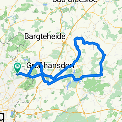
Sasel, Kupferteich, Wittmoor, Duvenstedter Brook und Volksdorf
A cycling route starting in Sasel, City state of Hamburg, Germany.
Overview
About this route
From Sasel, along quiet paths by the Kupferteich to the Wittmoor. Part of the route (about 1 km) is closed to bicycles. However, it is definitely worth experiencing this section. The journey continues through a piece of heathland to Duvenstedt. On small paths it then leads into the Duvenstedter Brook, mostly through nature via Hoisdorf and Volksdorf back to Sasel.
- -:--
- Duration
- 32.4 km
- Distance
- 101 m
- Ascent
- 97 m
- Descent
- ---
- Avg. speed
- ---
- Max. altitude

Route quality
Waytypes & surfaces along the route
Waytypes
Track
9.1 km
(28 %)
Path
9.1 km
(28 %)
Surfaces
Paved
12.3 km
(38 %)
Unpaved
17.2 km
(53 %)
Asphalt
11.7 km
(36 %)
Gravel
8.4 km
(26 %)
Route highlights
Points of interest along the route
Point of interest after 9.1 km
Schiebestrecke. Hier wurde von den Gefangenen des KZ Wittmoor 1933 Torf abgebaut. Die Gedenkstätte an der Ihr vorbeigekommen seid erinnert an diese Menschen.
Point of interest after 13.3 km
Hier im Eiscafe lohnt sich eine Pause
Point of interest after 16.3 km
Das Gasthaus Zum Bäcker ist auf ein Bier oder zum Essen zu empfehlen
Continue with Bikemap
Use, edit, or download this cycling route
You would like to ride Sasel, Kupferteich, Wittmoor, Duvenstedter Brook und Volksdorf or customize it for your own trip? Here is what you can do with this Bikemap route:
Free features
- Save this route as favorite or in collections
- Copy & plan your own version of this route
- Sync your route with Garmin or Wahoo
Premium features
Free trial for 3 days, or one-time payment. More about Bikemap Premium.
- Navigate this route on iOS & Android
- Export a GPX / KML file of this route
- Create your custom printout (try it for free)
- Download this route for offline navigation
Discover more Premium features.
Get Bikemap PremiumFrom our community
Other popular routes starting in Sasel
 Entspannter Feierabend
- Distance
- 42.1 km
- Ascent
- 92 m
- Descent
- 95 m
- Location
- Sasel, City state of Hamburg, Germany
 50 km um den Lütjensee
- Distance
- 50.1 km
- Ascent
- 153 m
- Descent
- 153 m
- Location
- Sasel, City state of Hamburg, Germany
 Von Sasel durch den Höltingbaum
- Distance
- 25.6 km
- Ascent
- 94 m
- Descent
- 94 m
- Location
- Sasel, City state of Hamburg, Germany
 Von Sasel rund um und durch den Brook
- Distance
- 33.2 km
- Ascent
- 88 m
- Descent
- 91 m
- Location
- Sasel, City state of Hamburg, Germany
 Volksdorfer Runde
- Distance
- 69.7 km
- Ascent
- 239 m
- Descent
- 240 m
- Location
- Sasel, City state of Hamburg, Germany
 tunneltal
- Distance
- 22.1 km
- Ascent
- 80 m
- Descent
- 83 m
- Location
- Sasel, City state of Hamburg, Germany
 Von Sasel um den Großensse
- Distance
- 53.7 km
- Ascent
- 121 m
- Descent
- 122 m
- Location
- Sasel, City state of Hamburg, Germany
 Von Sasel durch den Ohlsdorfer Friedhof
- Distance
- 20.2 km
- Ascent
- 92 m
- Descent
- 90 m
- Location
- Sasel, City state of Hamburg, Germany
Open it in the app