

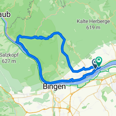
2017.02.26_Rheinrunde
A cycling route starting in Oestrich-Winkel, Rhineland-Palatinate, Germany.
Overview
About this route
- -:--
- Duration
- 54.1 km
- Distance
- 28 m
- Ascent
- 27 m
- Descent
- ---
- Avg. speed
- ---
- Max. altitude
Route quality
Waytypes & surfaces along the route
Waytypes
Track
26.5 km
(49 %)
Quiet road
10.8 km
(20 %)
Surfaces
Paved
43.8 km
(81 %)
Unpaved
1.6 km
(3 %)
Asphalt
40.6 km
(75 %)
Paved (undefined)
1.6 km
(3 %)
Continue with Bikemap
Use, edit, or download this cycling route
You would like to ride 2017.02.26_Rheinrunde or customize it for your own trip? Here is what you can do with this Bikemap route:
Free features
- Save this route as favorite or in collections
- Copy & plan your own version of this route
- Sync your route with Garmin or Wahoo
Premium features
Free trial for 3 days, or one-time payment. More about Bikemap Premium.
- Navigate this route on iOS & Android
- Export a GPX / KML file of this route
- Create your custom printout (try it for free)
- Download this route for offline navigation
Discover more Premium features.
Get Bikemap PremiumFrom our community
Other popular routes starting in Oestrich-Winkel
 Rheingau 1
- Distance
- 33 km
- Ascent
- 182 m
- Descent
- 182 m
- Location
- Oestrich-Winkel, Rhineland-Palatinate, Germany
 Route zu Kloster Johannisberg
- Distance
- 28.6 km
- Ascent
- 364 m
- Descent
- 364 m
- Location
- Oestrich-Winkel, Rhineland-Palatinate, Germany
 Mittelheim, 7 Wegweiser, Kalte Herberge, Hallgartner Zange, Mittelheim
- Distance
- 21.1 km
- Ascent
- 535 m
- Descent
- 535 m
- Location
- Oestrich-Winkel, Rhineland-Palatinate, Germany
 Monte Presso
- Distance
- 47 km
- Ascent
- 599 m
- Descent
- 598 m
- Location
- Oestrich-Winkel, Rhineland-Palatinate, Germany
 Route in Geisenheim
- Distance
- 34.4 km
- Ascent
- 502 m
- Descent
- 502 m
- Location
- Oestrich-Winkel, Rhineland-Palatinate, Germany
 Sonntagsrunde mit Kathrin
- Distance
- 20.3 km
- Ascent
- 300 m
- Descent
- 300 m
- Location
- Oestrich-Winkel, Rhineland-Palatinate, Germany
 Mittelheim_Lenneberg_Schwabenheim
- Distance
- 48.8 km
- Ascent
- 184 m
- Descent
- 187 m
- Location
- Oestrich-Winkel, Rhineland-Palatinate, Germany
 Vordertaunus-Wispertal
- Distance
- 57.3 km
- Ascent
- 735 m
- Descent
- 735 m
- Location
- Oestrich-Winkel, Rhineland-Palatinate, Germany
Open it in the app