

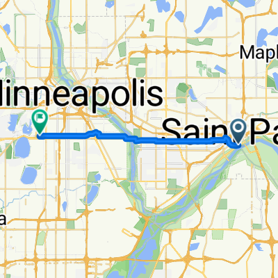
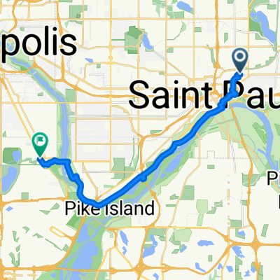
B2B00170 55117>55104 via front, hamline ped bridge, griggs, and selby
A cycling route starting in Saint Paul, Minnesota, United States.
Overview
About this route
Cross railroad tracks via hamline ped bridge
Cross 94 via Griggs ped bridge
- -:--
- Duration
- 9 km
- Distance
- 24 m
- Ascent
- 10 m
- Descent
- ---
- Avg. speed
- 284 m
- Max. altitude

Route quality
Waytypes & surfaces along the route
Waytypes
Quiet road
6.1 km
(68 %)
Road
1.7 km
(19 %)
Surfaces
Paved
2.4 km
(26 %)
Asphalt
2 km
(22 %)
Concrete
0.3 km
(3 %)
Continue with Bikemap
Use, edit, or download this cycling route
You would like to ride B2B00170 55117>55104 via front, hamline ped bridge, griggs, and selby or customize it for your own trip? Here is what you can do with this Bikemap route:
Free features
- Save this route as favorite or in collections
- Copy & plan your own version of this route
- Sync your route with Garmin or Wahoo
Premium features
Free trial for 3 days, or one-time payment. More about Bikemap Premium.
- Navigate this route on iOS & Android
- Export a GPX / KML file of this route
- Create your custom printout (try it for free)
- Download this route for offline navigation
Discover more Premium features.
Get Bikemap PremiumFrom our community
Other popular routes starting in Saint Paul
 B2B00192 55102>55404viaShepherdRd/MissBlvd/WRiverPkwy/MidtwnGrnway
- Distance
- 21.8 km
- Ascent
- 131 m
- Descent
- 86 m
- Location
- Saint Paul, Minnesota, United States
 B2B00062 55106 - 55075 via Concord, NURT
- Distance
- 9.5 km
- Ascent
- 80 m
- Descent
- 110 m
- Location
- Saint Paul, Minnesota, United States
 B2B00024 55104 > 55121 via Big Rivers Trail
- Distance
- 16.8 km
- Ascent
- 174 m
- Descent
- 174 m
- Location
- Saint Paul, Minnesota, United States
 To the River Center
- Distance
- 17.1 km
- Ascent
- 117 m
- Descent
- 90 m
- Location
- Saint Paul, Minnesota, United States
 Gateway State Trail
- Distance
- 30 km
- Ascent
- 115 m
- Descent
- 69 m
- Location
- Saint Paul, Minnesota, United States
 B2B00170 55117>55104 via front, hamline ped bridge, griggs, and selby
- Distance
- 9 km
- Ascent
- 24 m
- Descent
- 10 m
- Location
- Saint Paul, Minnesota, United States
 Jackson Street to East 7th Street
- Distance
- 1.6 km
- Ascent
- 36 m
- Descent
- 0 m
- Location
- Saint Paul, Minnesota, United States
 From Saint Paul to Minneapolis
- Distance
- 19.2 km
- Ascent
- 179 m
- Descent
- 191 m
- Location
- Saint Paul, Minnesota, United States
Open it in the app