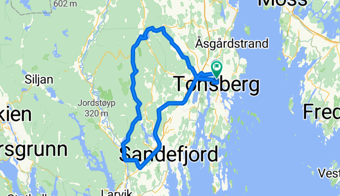
Høyjord, Kodal, Ringdal mv
A cycling route starting in Tønsberg, Vestfold, Norway.
Overview
About this route
- -:--
- Duration
- 99.4 km
- Distance
- 506 m
- Ascent
- 511 m
- Descent
- ---
- Avg. speed
- ---
- Avg. speed
Route quality
Waytypes & surfaces along the route
Waytypes
Busy road
65 km
(65 %)
Cycleway
16.9 km
(17 %)
Surfaces
Paved
70.3 km
(71 %)
Unpaved
0.2 km
(<1 %)
Asphalt
70.3 km
(71 %)
Gravel
0.2 km
(<1 %)
Undefined
29 km
(29 %)
Route highlights
Points of interest along the route
Point of interest after 62.9 km
Kaffestopp
Continue with Bikemap
Use, edit, or download this cycling route
You would like to ride Høyjord, Kodal, Ringdal mv or customize it for your own trip? Here is what you can do with this Bikemap route:
Free features
- Save this route as favorite or in collections
- Copy & plan your own version of this route
- Sync your route with Garmin or Wahoo
Premium features
Free trial for 3 days, or one-time payment. More about Bikemap Premium.
- Navigate this route on iOS & Android
- Export a GPX / KML file of this route
- Create your custom printout (try it for free)
- Download this route for offline navigation
Discover more Premium features.
Get Bikemap PremiumFrom our community
Other popular routes starting in Tønsberg
- Flat tur sydover
- Distance
- 95.5 km
- Ascent
- 417 m
- Descent
- 419 m
- Location
- Tønsberg, Vestfold, Norway
- 98. Tønsberg to Oslo
- Distance
- 108.3 km
- Ascent
- 908 m
- Descent
- 892 m
- Location
- Tønsberg, Vestfold, Norway
- 55km Småkupert om Slagendalen & Ramnes
- Distance
- 54.1 km
- Ascent
- 371 m
- Descent
- 371 m
- Location
- Tønsberg, Vestfold, Norway
- Onsdag 290317
- Distance
- 67.2 km
- Ascent
- ---
- Descent
- ---
- Location
- Tønsberg, Vestfold, Norway
- Kyststien og Hortensmarka
- Distance
- 51.6 km
- Ascent
- 410 m
- Descent
- 411 m
- Location
- Tønsberg, Vestfold, Norway
- Glava Tour 2013, stage 3: Tønsberg-Drammen
- Distance
- 127.9 km
- Ascent
- 660 m
- Descent
- 659 m
- Location
- Tønsberg, Vestfold, Norway
- Barkåker Stokke
- Distance
- 37.8 km
- Ascent
- 194 m
- Descent
- 212 m
- Location
- Tønsberg, Vestfold, Norway
- TCK over Vidaråsen
- Distance
- 71.7 km
- Ascent
- 423 m
- Descent
- 423 m
- Location
- Tønsberg, Vestfold, Norway