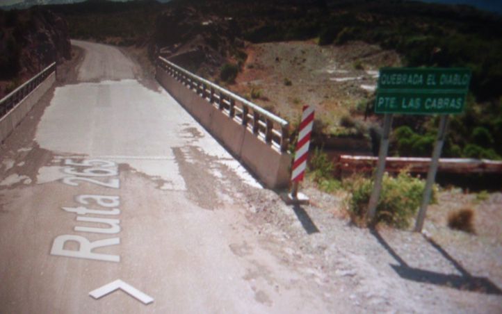
CHILE CHICO a QUEBRADA EL DIABLO
A cycling route starting in Chile Chico, Aysén, Chile.
Overview
About this route
Recorrido por la ruta 265 de Chile, camino de ripio con grandes subidas. Pasando por rios, quebradas, valles, cerros, montañas, camino de trincheras en varios lugares y la famosa Laguna Verde que es la estrella del lugar,,
Tambien se pasa por un camino pegado al Lago General Carreras,,Gran Aventura Biker.
- -:--
- Duration
- 35 km
- Distance
- 733 m
- Ascent
- 636 m
- Descent
- ---
- Avg. speed
- ---
- Max. altitude
Route quality
Waytypes & surfaces along the route
Waytypes
Track
1.8 km
(5 %)
Path
0.4 km
(1 %)
Undefined
32.9 km
(94 %)
Surfaces
Unpaved
32.9 km
(94 %)
Gravel
31.9 km
(91 %)
Unpaved (undefined)
1.1 km
(3 %)
Undefined
2.1 km
(6 %)
Route highlights
Points of interest along the route
Point of interest after 1.8 km
FABRICA

Point of interest after 2.4 km
ARROYO BURGOS
Point of interest after 8.4 km
ESTERO- LAS CHACRAS

Point of interest after 14.2 km
RIO- EL BAÑO

Point of interest after 20.8 km
LAGUNA VERDE. ESPECTACULAR LUGAR. TIENE MIRADOR.

Point of interest after 20.9 km
LAGUNA VERDE
Point of interest after 23.8 km
COMPANIA MINERA CERRO BAYO

Point of interest after 26 km
ARROYO EL RODEO

Point of interest after 31.1 km
LAGO GENERAL CARRERAS

Point of interest after 32.9 km
QUEBRADA DE LAS HORQUETAS. RIO SAN ALFONSO

Point of interest after 35 km
RIO Y QUEBRADA EL DIABLO
Continue with Bikemap
Use, edit, or download this cycling route
You would like to ride CHILE CHICO a QUEBRADA EL DIABLO or customize it for your own trip? Here is what you can do with this Bikemap route:
Free features
- Save this route as favorite or in collections
- Copy & plan your own version of this route
- Sync your route with Garmin or Wahoo
Premium features
Free trial for 3 days, or one-time payment. More about Bikemap Premium.
- Navigate this route on iOS & Android
- Export a GPX / KML file of this route
- Create your custom printout (try it for free)
- Download this route for offline navigation
Discover more Premium features.
Get Bikemap PremiumFrom our community
Other popular routes starting in Chile Chico
 De Costanera, Chile Chico a Lautaro 260, Chile Chico
- Distance
- 13.6 km
- Ascent
- 76 m
- Descent
- 72 m
- Location
- Chile Chico, Aysén, Chile
 Recovered Route
- Distance
- 11.5 km
- Ascent
- 191 m
- Descent
- 12 m
- Location
- Chile Chico, Aysén, Chile
 CHILE CHICO a QUEBRADA EL DIABLO
- Distance
- 35 km
- Ascent
- 733 m
- Descent
- 636 m
- Location
- Chile Chico, Aysén, Chile
 16_2_KEMP V CHILE CHICO
- Distance
- 1.2 km
- Ascent
- 4 m
- Descent
- 52 m
- Location
- Chile Chico, Aysén, Chile
 ChileChico-VillaOHiggins
- Distance
- 316.5 km
- Ascent
- 8,386 m
- Descent
- 8,298 m
- Location
- Chile Chico, Aysén, Chile
 17_CHILE CHICO-LOS ANTIGUOS-CHILE CHICO
- Distance
- 29.8 km
- Ascent
- 83 m
- Descent
- 83 m
- Location
- Chile Chico, Aysén, Chile
 13.Tag
- Distance
- 100.8 km
- Ascent
- 653 m
- Descent
- 767 m
- Location
- Chile Chico, Aysén, Chile
 Carretera Austral 15.Etappe Chile Chico - Fachinal
- Distance
- 46.8 km
- Ascent
- 825 m
- Descent
- 830 m
- Location
- Chile Chico, Aysén, Chile
Open it in the app


