Trilhas do Saint Hilaire
A cycling route starting in Viamão, Rio Grande do Sul, Brazil.
Overview
About this route
Some MTB trails in Saint Hilaire Park, ideal for XC, Single Track. It's best to go in the morning for the temperature and safety (you never know, although I've been there a lot and nothing ever happened)
- -:--
- Duration
- 20.9 km
- Distance
- 362 m
- Ascent
- 361 m
- Descent
- ---
- Avg. speed
- ---
- Max. altitude
Continue with Bikemap
Use, edit, or download this cycling route
You would like to ride Trilhas do Saint Hilaire or customize it for your own trip? Here is what you can do with this Bikemap route:
Free features
- Save this route as favorite or in collections
- Copy & plan your own version of this route
- Sync your route with Garmin or Wahoo
Premium features
Free trial for 3 days, or one-time payment. More about Bikemap Premium.
- Navigate this route on iOS & Android
- Export a GPX / KML file of this route
- Create your custom printout (try it for free)
- Download this route for offline navigation
Discover more Premium features.
Get Bikemap PremiumFrom our community
Other popular routes starting in Viamão
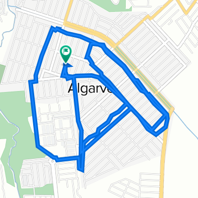
- -30.030° N -51.083° W a -29.996° N -51.057° W
- Distance
- 6.4 km
- Ascent
- 95 m
- Descent
- 111 m
- Location
- Viamão, Rio Grande do Sul, Brazil
- Não faça!
- Distance
- 5.2 km
- Ascent
- 74 m
- Descent
- 99 m
- Location
- Viamão, Rio Grande do Sul, Brazil
- Trilhas do Saint Hilaire
- Distance
- 20.9 km
- Ascent
- 362 m
- Descent
- 361 m
- Location
- Viamão, Rio Grande do Sul, Brazil
- SNG1 _ poa / palmares do sul
- Distance
- 77.7 km
- Ascent
- 224 m
- Descent
- 301 m
- Location
- Viamão, Rio Grande do Sul, Brazil
- Route to Rua Walt Disney, 233, 94415-550, Viamão
- Distance
- 31.5 km
- Ascent
- 455 m
- Descent
- 456 m
- Location
- Viamão, Rio Grande do Sul, Brazil
- Rota supersônica em Viamão
- Distance
- 42.3 km
- Ascent
- 270 m
- Descent
- 303 m
- Location
- Viamão, Rio Grande do Sul, Brazil
- De Rua Ag 649 a Avenida João Carlos Viale Dias 1421-1513
- Distance
- 8.3 km
- Ascent
- 133 m
- Descent
- 131 m
- Location
- Viamão, Rio Grande do Sul, Brazil
- Matamala saindo pela Restinga e voltando ao Suco
- Distance
- 19.1 km
- Ascent
- 481 m
- Descent
- 483 m
- Location
- Viamão, Rio Grande do Sul, Brazil
Open it in the app