

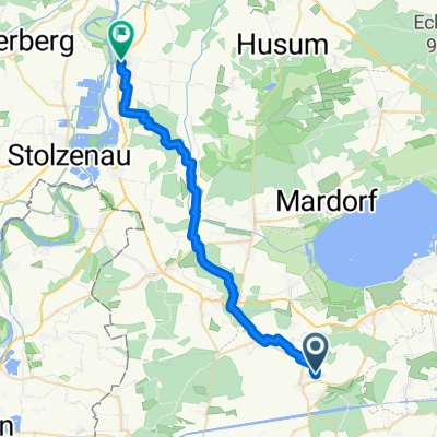
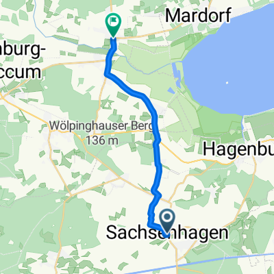
Storchenroute in der Samtgemeinde Sachsenhagen
A cycling route starting in Sachsenhagen, Lower Saxony, Germany.
Overview
About this route
The circular tour goes through the Samtgemeinde Sachsenhagen, past ten stork nests and four nesting aids.
Best time of year: March to July.
Route length: approx. 30 km.
Route character: Predominantly on gravel or paved farm roads and bike paths. There is only one ascent to tackle on the mostly flat route. Not suitable for racing bikes. The route starts and ends at the Schützenplatz Sachsenhagen. Parking facilities are available here. The numerous places to stop are marked with POI's.
About nature conservation: Please do not leave the paths and do not disturb the nesting process. Don't forget your binoculars. The beautiful landscape serves as a habitat for the storks and many other animals. The nests are not occupied every year.
To the left, passing the old fire department equipment house, the path leads over the Aue into the fields. If you look back, to the right and left, you can spot the first four stork nests. In Nienbrügge, you ride directly towards a stork nest that stands in the oaks on a pole. Coming out of Nienbrügge, you see a nesting aid on the right before the intersection. Once you reach Bergkirchen, you can spot a nesting aid on the right. On the ridge, you have a wonderful view of the Steinhuder Meer. In Schmalenbruch, after about 1500 m behind the town sign, on the right at the Stromhäuschen, there is a solid nesting aid. In the forest before Hagenburg, you can spot the enamored beech trees. Pay attention to the POI. In Hagenburg, past the Försterteich and the castle. There are numerous places to stop here. The nest in Hagenburg can be found along the bike path through the gardens. Under the first nest in Auhagen, you can stop at a café. In addition, you pass a restaurant in Auhagen. At the stork nest on the old upholstered furniture factory in Sachsenhagen, there is a snack bar. Have fun.
- -:--
- Duration
- 30.2 km
- Distance
- 120 m
- Ascent
- 118 m
- Descent
- ---
- Avg. speed
- ---
- Max. altitude
Route quality
Waytypes & surfaces along the route
Waytypes
Path
10 km
(33 %)
Track
8.5 km
(28 %)
Surfaces
Paved
17.5 km
(58 %)
Unpaved
8.8 km
(29 %)
Asphalt
13.3 km
(44 %)
Gravel
6 km
(20 %)
Route highlights
Points of interest along the route
Point of interest after 0 km
Bistro und Döneria

Point of interest after 0.6 km
Sorchennester Sachsenhagen
Point of interest after 4.3 km
Restaurant und Fahrradwerkstatt
Point of interest after 4.5 km
Storchennest Nienbrügge
Point of interest after 5.9 km
Nisthilfe
Point of interest after 8.9 km
Nisthilfe Bergkirchen
Point of interest after 10 km
Aussichtspunkt Steinhuder Meer.
Point of interest after 12.2 km
Nisthilfe

Point of interest after 16.7 km
Verliebte Buchen. Auf der rechten Seite vor der Gabelung stehen zwei zusammengewachsene Buchen. Auf den Wanderweghinweis achten.
Point of interest after 18.5 km
Rhododendronallee
Point of interest after 19.1 km
Moorgarten Cafe und Biergarten
Point of interest after 19.3 km
Findlingsgarten
Point of interest after 19.5 km
Biergarten
Point of interest after 19.7 km
Gaststätte
Point of interest after 20.3 km
Biergarten
Point of interest after 20.6 km
Storchennest Hagenburg
Point of interest after 21.6 km
Fischimbiss
Point of interest after 24 km
Storchennest Auhagen und Cafe
Point of interest after 25.2 km
Storchennest Auhagen
Point of interest after 26.8 km
Restaurant
Point of interest after 28.5 km
Imbiss
Point of interest after 28.7 km
Storchennest auf der alten Polstermöbelfabrik
Point of interest after 28.9 km
Storchennest auf einer Tanne
Point of interest after 29 km
Storchennest auf Conradis Mühle
Point of interest after 29.5 km
Nisthilfe
Point of interest after 29.9 km
Storchennest auf der alten Schule.

Point of interest after 30.2 km
Storchennest auf dem alten Feuerwehrgerätehaus.
Continue with Bikemap
Use, edit, or download this cycling route
You would like to ride Storchenroute in der Samtgemeinde Sachsenhagen or customize it for your own trip? Here is what you can do with this Bikemap route:
Free features
- Save this route as favorite or in collections
- Copy & plan your own version of this route
- Sync your route with Garmin or Wahoo
Premium features
Free trial for 3 days, or one-time payment. More about Bikemap Premium.
- Navigate this route on iOS & Android
- Export a GPX / KML file of this route
- Create your custom printout (try it for free)
- Download this route for offline navigation
Discover more Premium features.
Get Bikemap PremiumFrom our community
Other popular routes starting in Sachsenhagen
 Von Ricklingen nach Bassum Stage 4 PAUSE
- Distance
- 26.5 km
- Ascent
- 169 m
- Descent
- 195 m
- Location
- Sachsenhagen, Lower Saxony, Germany
 Düdinghäuser Berg bis Loccumer Berg CLONED FROM ROUTE 942754
- Distance
- 28.8 km
- Ascent
- 394 m
- Descent
- 393 m
- Location
- Sachsenhagen, Lower Saxony, Germany
 Leibnizring 6, Sachsenhagen nach Schaumburger Weg 49, Stadthagen
- Distance
- 17.5 km
- Ascent
- 180 m
- Descent
- 95 m
- Location
- Sachsenhagen, Lower Saxony, Germany
 Storchenroute in der Samtgemeinde Sachsenhagen
- Distance
- 30.2 km
- Ascent
- 120 m
- Descent
- 118 m
- Location
- Sachsenhagen, Lower Saxony, Germany
 Heisterberg-Bückeberg-Harrl über den Kamm
- Distance
- 74 km
- Ascent
- 518 m
- Descent
- 520 m
- Location
- Sachsenhagen, Lower Saxony, Germany
 Gödenstraße 6, Sachsenhagen nach Heidtorstraße 47, Rehburg-Loccum
- Distance
- 11.4 km
- Ascent
- 64 m
- Descent
- 78 m
- Location
- Sachsenhagen, Lower Saxony, Germany
 Sachsenhagen- Köterberg
- Distance
- 91.1 km
- Ascent
- 1,204 m
- Descent
- 775 m
- Location
- Sachsenhagen, Lower Saxony, Germany
 Steinhudermeer 2
- Distance
- 49.4 km
- Ascent
- 81 m
- Descent
- 80 m
- Location
- Sachsenhagen, Lower Saxony, Germany
Open it in the app