

Abwechslungsreiche Rennrad-Tour
A cycling route starting in Sindelfingen, Baden-Wurttemberg, Germany.
Overview
About this route
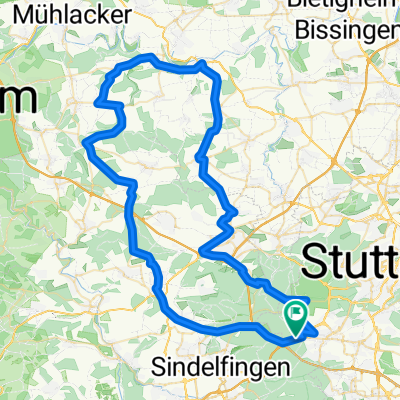
Sindelfingen, Herrenberg, Tübingen, Holzgerlingen. Up to Tübingen you can roll along calmly and also enjoy the landscape that leads through really beautiful villages on less frequented roads. TÜ itself certainly invites you to take a break. But be careful - you will need real strength for the return from Tübingen. The climb from the Neckar valley to Sohienpflege is tough, and afterwards it is not flat either. The descent to Dettenhausen is steep, allowing you to reach over 70 km/h. Further towards Weil im Schönbuch, you will face another good climb. So, allocate your energy wisely. The gentle incline through Holzgerlingen is rewarded with a nice descent towards Böblingen. But there, please use the road, as the bike path, while paved and wide, intersects in the curves with the well-used cycling route, posing a significant risk of accidents.
- -:--
- Duration
- 70 km
- Distance
- 479 m
- Ascent
- 451 m
- Descent
- ---
- Avg. speed
- 519 m
- Max. altitude
Route quality
Waytypes & surfaces along the route
Waytypes
Road
21 km
(30 %)
Track
7 km
(10 %)
Surfaces
Paved
66.5 km
(95 %)
Unpaved
2.1 km
(3 %)
Asphalt
65.1 km
(93 %)
Ground
2.1 km
(3 %)
Route highlights
Points of interest along the route
Point of interest after 3.4 km
Point of interest after 5.1 km
Continue with Bikemap
Use, edit, or download this cycling route
You would like to ride Abwechslungsreiche Rennrad-Tour or customize it for your own trip? Here is what you can do with this Bikemap route:
Free features
- Save this route as favorite or in collections
- Copy & plan your own version of this route
- Sync your route with Garmin or Wahoo
Premium features
Free trial for 3 days, or one-time payment. More about Bikemap Premium.
- Navigate this route on iOS & Android
- Export a GPX / KML file of this route
- Create your custom printout (try it for free)
- Download this route for offline navigation
Discover more Premium features.
Get Bikemap PremiumFrom our community
Other popular routes starting in Sindelfingen
 einfach drauf los
- Distance
- 36.7 km
- Ascent
- 391 m
- Descent
- 389 m
- Location
- Sindelfingen, Baden-Wurttemberg, Germany
 S-Vaihingen Renningen Mönse Iptingen Gr-Glattbach Enzweihingen Heimse Leo
- Distance
- 79.4 km
- Ascent
- 878 m
- Descent
- 975 m
- Location
- Sindelfingen, Baden-Wurttemberg, Germany
 Sifi - Magstadt - Renningen/Weinberg - Malmsheim - Weil d. Stadt - Döffingen - Sifi
- Distance
- 36.6 km
- Ascent
- 196 m
- Descent
- 196 m
- Location
- Sindelfingen, Baden-Wurttemberg, Germany
 Runde Kaltenbronn
- Distance
- 152.5 km
- Ascent
- 2,273 m
- Descent
- 2,273 m
- Location
- Sindelfingen, Baden-Wurttemberg, Germany
 Parkhotel Leinfelden Echterdingen und Siebenmühlental
- Distance
- 30 km
- Ascent
- 302 m
- Descent
- 302 m
- Location
- Sindelfingen, Baden-Wurttemberg, Germany
 Kurze Runde um BB (62,5km)
- Distance
- 62.5 km
- Ascent
- 454 m
- Descent
- 439 m
- Location
- Sindelfingen, Baden-Wurttemberg, Germany
 Lange Runde durch den Nordschwarzwald
- Distance
- 172.3 km
- Ascent
- 2,412 m
- Descent
- 2,413 m
- Location
- Sindelfingen, Baden-Wurttemberg, Germany
 Vaihingen Baerenschloessle
- Distance
- 6.2 km
- Ascent
- 94 m
- Descent
- 166 m
- Location
- Sindelfingen, Baden-Wurttemberg, Germany
Open it in the app