

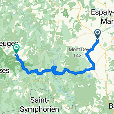
27 avril - Bains vers Lanarce
A cycling route starting in Bains, Auvergne-Rhône-Alpes, France.
Overview
About this route
- -:--
- Duration
- 42.9 km
- Distance
- 468 m
- Ascent
- 344 m
- Descent
- ---
- Avg. speed
- ---
- Max. altitude

Route quality
Waytypes & surfaces along the route
Waytypes
Road
15.5 km
(36 %)
Track
10.7 km
(25 %)
Surfaces
Paved
12 km
(28 %)
Unpaved
6.9 km
(16 %)
Asphalt
10.7 km
(25 %)
Ground
5.2 km
(12 %)
Continue with Bikemap
Use, edit, or download this cycling route
You would like to ride 27 avril - Bains vers Lanarce or customize it for your own trip? Here is what you can do with this Bikemap route:
Free features
- Save this route as favorite or in collections
- Copy & plan your own version of this route
- Sync your route with Garmin or Wahoo
Premium features
Free trial for 3 days, or one-time payment. More about Bikemap Premium.
- Navigate this route on iOS & Android
- Export a GPX / KML file of this route
- Create your custom printout (try it for free)
- Download this route for offline navigation
Discover more Premium features.
Get Bikemap PremiumFrom our community
Other popular routes starting in Bains
 De Saint-Christophe-sur-Dolaison à Saugues
- Distance
- 50.7 km
- Ascent
- 1,642 m
- Descent
- 1,581 m
- Location
- Bains, Auvergne-Rhône-Alpes, France
 Circuit vacs départ du Puy
- Distance
- 94.4 km
- Ascent
- 1,419 m
- Descent
- 1,419 m
- Location
- Bains, Auvergne-Rhône-Alpes, France
 ard etape4
- Distance
- 73.8 km
- Ascent
- 1,602 m
- Descent
- 1,692 m
- Location
- Bains, Auvergne-Rhône-Alpes, France
 Holidays on bike
- Distance
- 139.9 km
- Ascent
- 1,702 m
- Descent
- 1,851 m
- Location
- Bains, Auvergne-Rhône-Alpes, France
 3 - Bains-StAlbanSurLimagnole
- Distance
- 56.2 km
- Ascent
- 918 m
- Descent
- 949 m
- Location
- Bains, Auvergne-Rhône-Alpes, France
 St-Privat-D'allier
- Distance
- 50.6 km
- Ascent
- 803 m
- Descent
- 784 m
- Location
- Bains, Auvergne-Rhône-Alpes, France
 Apocalypse selon Saint-Béru
- Distance
- 68.5 km
- Ascent
- 966 m
- Descent
- 966 m
- Location
- Bains, Auvergne-Rhône-Alpes, France
 27 avril - Bains vers Lanarce
- Distance
- 42.9 km
- Ascent
- 468 m
- Descent
- 344 m
- Location
- Bains, Auvergne-Rhône-Alpes, France
Open it in the app