

3etapa febrero
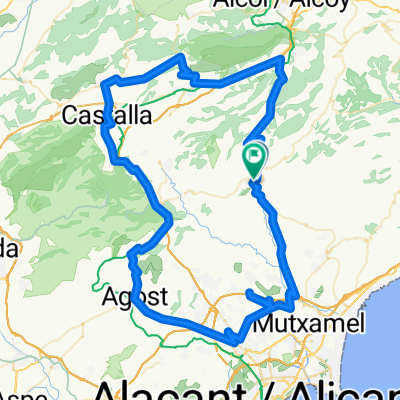
A cycling route starting in Xixona, Valencia, Spain.
Overview
About this route
- -:--
- Duration
- 119.1 km
- Distance
- 1,249 m
- Ascent
- 1,258 m
- Descent
- ---
- Avg. speed
- ---
- Max. altitude

Route highlights
Points of interest along the route
Point of interest after 0.4 km
llegada
Point of interest after 12.3 km
alto carrasqueta
Point of interest after 17.5 km
empieza puerto
Point of interest after 24 km
direccion xixona
Point of interest after 26.1 km
salida ibi
Point of interest after 27.5 km
cruce izquierda
Point of interest after 28.6 km
ibi
Point of interest after 30.9 km
puerto vueltas
Point of interest after 32.6 km
cruce derecha
Point of interest after 40.3 km
empieza puerto
Point of interest after 41.6 km
cruce subida
Point of interest after 44.5 km
crce onil
Point of interest after 47.6 km
bar stop
Point of interest after 52.6 km
cruce cati
Point of interest after 55.4 km
cruce2
Point of interest after 62.5 km
cruce
Point of interest after 72 km
salida agost
Continue with Bikemap
Use, edit, or download this cycling route
You would like to ride 3etapa febrero or customize it for your own trip? Here is what you can do with this Bikemap route:
Free features
- Save this route as favorite or in collections
- Copy & plan your own version of this route
- Split it into stages to create a multi-day tour
- Sync your route with Garmin or Wahoo
Premium features
Free trial for 3 days, or one-time payment. More about Bikemap Premium.
- Navigate this route on iOS & Android
- Export a GPX / KML file of this route
- Create your custom printout (try it for free)
- Download this route for offline navigation
Discover more Premium features.
Get Bikemap PremiumFrom our community
Other popular routes starting in Xixona
 Cima Mignorn por el Alto de la Martina
- Distance
- 30.6 km
- Ascent
- 921 m
- Descent
- 924 m
- Location
- Xixona, Valencia, Spain
 Ruta 39: Xixona - Ibi - Alcoy
- Distance
- 43.8 km
- Ascent
- 1,049 m
- Descent
- 881 m
- Location
- Xixona, Valencia, Spain
 Xixona -Milleneta-Gorga-Quatretondeta-Benasau-Penaguila-Benifallin-torremanzanas-Xixona
- Distance
- 83 km
- Ascent
- 1,488 m
- Descent
- 1,498 m
- Location
- Xixona, Valencia, Spain
 3etapa febrero
- Distance
- 118.9 km
- Ascent
- 1,249 m
- Descent
- 1,258 m
- Location
- Xixona, Valencia, Spain
 Xixona -Milleneta-Gorga-Quatretondeta-Benasau-Penaguila-Benifallin-torremanzanas-Xixona
- Distance
- 83.1 km
- Ascent
- 1,488 m
- Descent
- 1,498 m
- Location
- Xixona, Valencia, Spain
 Xixona-Beniarres-Planes-Gorga-Benifallin-Torremanzanas-Xixona
- Distance
- 114 km
- Ascent
- 1,573 m
- Descent
- 1,582 m
- Location
- Xixona, Valencia, Spain
 XIXONA-CARRASQUETA-CONFRIDES-FINESTRAT-JIJONA
- Distance
- 151.1 km
- Ascent
- 4,436 m
- Descent
- 4,438 m
- Location
- Xixona, Valencia, Spain
 RUTA MONTAÑA
- Distance
- 123.9 km
- Ascent
- 1,774 m
- Descent
- 1,723 m
- Location
- Xixona, Valencia, Spain
Open it in the app