

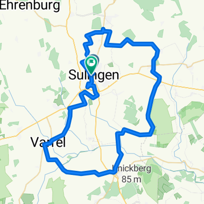
Harmhausen
A cycling route starting in Sulingen, Lower Saxony, Germany.
Overview
About this route
- -:--
- Duration
- 26.6 km
- Distance
- 73 m
- Ascent
- 74 m
- Descent
- ---
- Avg. speed
- ---
- Max. altitude
Route quality
Waytypes & surfaces along the route
Waytypes
Quiet road
15 km
(57 %)
Path
4.4 km
(17 %)
Surfaces
Paved
14.7 km
(55 %)
Unpaved
0.4 km
(2 %)
Asphalt
12.2 km
(46 %)
Paving stones
2.1 km
(8 %)
Continue with Bikemap
Use, edit, or download this cycling route
You would like to ride Harmhausen or customize it for your own trip? Here is what you can do with this Bikemap route:
Free features
- Save this route as favorite or in collections
- Copy & plan your own version of this route
- Sync your route with Garmin or Wahoo
Premium features
Free trial for 3 days, or one-time payment. More about Bikemap Premium.
- Navigate this route on iOS & Android
- Export a GPX / KML file of this route
- Create your custom printout (try it for free)
- Download this route for offline navigation
Discover more Premium features.
Get Bikemap PremiumFrom our community
Other popular routes starting in Sulingen
 Erdmannradweg - Südwestrunde
- Distance
- 30.4 km
- Ascent
- 56 m
- Descent
- 56 m
- Location
- Sulingen, Lower Saxony, Germany
 Rundtour - Sulingen ca 52 KM
- Distance
- 51.6 km
- Ascent
- 51 m
- Descent
- 61 m
- Location
- Sulingen, Lower Saxony, Germany
 Entspannt Unterwegs
- Distance
- 23.8 km
- Ascent
- 53 m
- Descent
- 49 m
- Location
- Sulingen, Lower Saxony, Germany
 7 Suinger Fahrradtour
- Distance
- 71 km
- Ascent
- 105 m
- Descent
- 103 m
- Location
- Sulingen, Lower Saxony, Germany
 Rundfahrt Sulingen
- Distance
- 56.9 km
- Ascent
- 79 m
- Descent
- 82 m
- Location
- Sulingen, Lower Saxony, Germany
 Geschwister-Scholl-Straße 6, Sulingen nach Hindenburgstraße 22A, Sulingen
- Distance
- 24.4 km
- Ascent
- 7 m
- Descent
- 13 m
- Location
- Sulingen, Lower Saxony, Germany
 Durchs nördliche Sulinger Land
- Distance
- 26.2 km
- Ascent
- 37 m
- Descent
- 34 m
- Location
- Sulingen, Lower Saxony, Germany
 Rundtour 3 - Land und Leute
- Distance
- 39.5 km
- Ascent
- 73 m
- Descent
- 74 m
- Location
- Sulingen, Lower Saxony, Germany
Open it in the app