

Förderverein der Peter-Witte-Schule
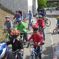
FÖV Tour 2017 – Botanischer Volkspark Blankenfelde-Pankow
A cycling route starting in Wittenau, State of Berlin, Germany.
Overview
About this route
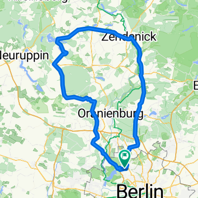
The route goes from Peter-Witte Elementary School, along the Wall cycle path, over the Lübarser Heights, through the Tegeler Flies, over the Schwarzwasser Lake to the Botanical Volkspark Blankenfelde-Pankow. Of course, the shortest way back to the school is taken.
The tour is also manageable for younger children and can be shortened spontaneously if necessary.
- -:--
- Duration
- 20.1 km
- Distance
- 82 m
- Ascent
- 82 m
- Descent
- ---
- Avg. speed
- ---
- Max. altitude

Part of
Route photos


Continue with Bikemap
Use, edit, or download this cycling route
You would like to ride FÖV Tour 2017 – Botanischer Volkspark Blankenfelde-Pankow or customize it for your own trip? Here is what you can do with this Bikemap route:
Free features
- Save this route as favorite or in collections
- Copy & plan your own version of this route
- Sync your route with Garmin or Wahoo
Premium features
Free trial for 3 days, or one-time payment. More about Bikemap Premium.
- Navigate this route on iOS & Android
- Export a GPX / KML file of this route
- Create your custom printout (try it for free)
- Download this route for offline navigation
Discover more Premium features.
Get Bikemap PremiumFrom our community
Other popular routes starting in Wittenau
 beste Rennradstrecke!!!!
- Distance
- 142.4 km
- Ascent
- 149 m
- Descent
- 149 m
- Location
- Wittenau, State of Berlin, Germany
 FÖV Tour 2018 – Strandbad Lübars "Kontraste der Großstadt"
- Distance
- 21.4 km
- Ascent
- 96 m
- Descent
- 91 m
- Location
- Wittenau, State of Berlin, Germany
 43 km Rundtour Henningsdorf, Schönwalde
- Distance
- 41.3 km
- Ascent
- 101 m
- Descent
- 101 m
- Location
- Wittenau, State of Berlin, Germany
 Ab zum Kindergarten
- Distance
- 14.9 km
- Ascent
- 147 m
- Descent
- 135 m
- Location
- Wittenau, State of Berlin, Germany
 FÖV Tour 2016 – Bürgerpark Pankow
- Distance
- 17.5 km
- Ascent
- 18 m
- Descent
- 18 m
- Location
- Wittenau, State of Berlin, Germany
 Nordgraben-Panke bearb.
- Distance
- 29.5 km
- Ascent
- 58 m
- Descent
- 60 m
- Location
- Wittenau, State of Berlin, Germany
 Wittenau-Waldspielplatz-Ludolfinger-Wittenau
- Distance
- 19.8 km
- Ascent
- 78 m
- Descent
- 75 m
- Location
- Wittenau, State of Berlin, Germany
 Berliner Norden
- Distance
- 39.7 km
- Ascent
- 97 m
- Descent
- 94 m
- Location
- Wittenau, State of Berlin, Germany
Open it in the app