
2017 Alps 7
A cycling route starting in Villeneuve, Provence-Alpes-Côte d'Azur Region, France.
Overview
About this route
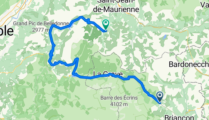
Lautaret, Sarenne, Croix de Fer, Molard, Lacets de Montvernier/Jaussy
- -:--
- Duration
- 119.5 km
- Distance
- 3,006 m
- Ascent
- 3,162 m
- Descent
- ---
- Avg. speed
- ---
- Max. altitude

Route quality
Waytypes & surfaces along the route
Waytypes
Road
17.9 km
(15 %)
Quiet road
11.9 km
(10 %)
Surfaces
Paved
76.5 km
(64 %)
Asphalt
76.5 km
(64 %)
Undefined
43 km
(36 %)
Continue with Bikemap
Use, edit, or download this cycling route
You would like to ride 2017 Alps 7 or customize it for your own trip? Here is what you can do with this Bikemap route:
Free features
- Save this route as favorite or in collections
- Copy & plan your own version of this route
- Split it into stages to create a multi-day tour
- Sync your route with Garmin or Wahoo
Premium features
Free trial for 3 days, or one-time payment. More about Bikemap Premium.
- Navigate this route on iOS & Android
- Export a GPX / KML file of this route
- Create your custom printout (try it for free)
- Download this route for offline navigation
Discover more Premium features.
Get Bikemap PremiumFrom our community
Other popular routes starting in Villeneuve
 za-Col dÍzoard-109 km B-weg
- Distance
- 108.5 km
- Ascent
- 3,928 m
- Descent
- 3,924 m
- Location
- Villeneuve, Provence-Alpes-Côte d'Azur Region, France
 ma-Galibier-96 km
- Distance
- 95.3 km
- Ascent
- 2,616 m
- Descent
- 2,901 m
- Location
- Villeneuve, Provence-Alpes-Côte d'Azur Region, France
 Serre Chevalier - Col du Galibier
- Distance
- 27.7 km
- Ascent
- 1,248 m
- Descent
- 31 m
- Location
- Villeneuve, Provence-Alpes-Côte d'Azur Region, France
 France Transalp Etappe7
- Distance
- 111.3 km
- Ascent
- 3,087 m
- Descent
- 3,456 m
- Location
- Villeneuve, Provence-Alpes-Côte d'Azur Region, France
 za-col d'Izoard-100 km-A weg
- Distance
- 99.7 km
- Ascent
- 3,139 m
- Descent
- 3,135 m
- Location
- Villeneuve, Provence-Alpes-Côte d'Azur Region, France
 2017 Alps 7
- Distance
- 119.5 km
- Ascent
- 3,006 m
- Descent
- 3,162 m
- Location
- Villeneuve, Provence-Alpes-Côte d'Azur Region, France
 Albertville - Col du Granon
- Distance
- 208.9 km
- Ascent
- 4,411 m
- Descent
- 6,449 m
- Location
- Villeneuve, Provence-Alpes-Côte d'Azur Region, France
 Mont Thabor
- Distance
- 35.2 km
- Ascent
- 1,997 m
- Descent
- 1,999 m
- Location
- Villeneuve, Provence-Alpes-Côte d'Azur Region, France
Open it in the app