
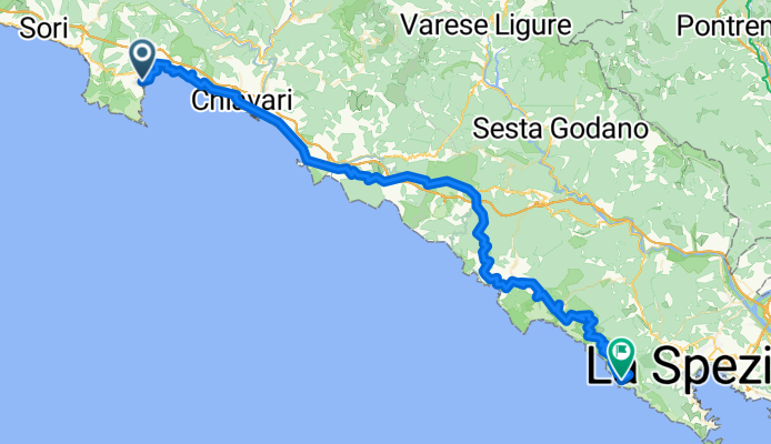
Evan Rapallo 5 Terre Riomaggiore
A cycling route starting in Santa Margherita Ligure, Liguria, Italy.
Overview
About this route
- -:--
- Duration
- 88.4 km
- Distance
- 1,636 m
- Ascent
- 1,440 m
- Descent
- ---
- Avg. speed
- ---
- Max. altitude

Route quality
Waytypes & surfaces along the route
Waytypes
Busy road
67.3 km
(76 %)
Quiet road
7.9 km
(9 %)
Surfaces
Paved
68.3 km
(77 %)
Unpaved
2 km
(2 %)
Asphalt
64 km
(72 %)
Paved (undefined)
4.2 km
(5 %)
Continue with Bikemap
Use, edit, or download this cycling route
You would like to ride Evan Rapallo 5 Terre Riomaggiore or customize it for your own trip? Here is what you can do with this Bikemap route:
Free features
- Save this route as favorite or in collections
- Copy & plan your own version of this route
- Split it into stages to create a multi-day tour
- Sync your route with Garmin or Wahoo
Premium features
Free trial for 3 days, or one-time payment. More about Bikemap Premium.
- Navigate this route on iOS & Android
- Export a GPX / KML file of this route
- Create your custom printout (try it for free)
- Download this route for offline navigation
Discover more Premium features.
Get Bikemap PremiumFrom our community
Other popular routes starting in Santa Margherita Ligure
 BDC Santa Uscio Crocetta
- Distance
- 66.9 km
- Ascent
- 1,915 m
- Descent
- 1,899 m
- Location
- Santa Margherita Ligure, Liguria, Italy
 sml-romaggi-crocetta-sml
- Distance
- 70.9 km
- Ascent
- 1,566 m
- Descent
- 1,568 m
- Location
- Santa Margherita Ligure, Liguria, Italy
 Da Corso Guglielmo Marconi 17, Santa Margherita Ligure a Piazza Cristoforo Colombo 33, Camogli
- Distance
- 25.3 km
- Ascent
- 2,051 m
- Descent
- 2,077 m
- Location
- Santa Margherita Ligure, Liguria, Italy
 Velva01
- Distance
- 44.4 km
- Ascent
- 881 m
- Descent
- 355 m
- Location
- Santa Margherita Ligure, Liguria, Italy
 Monte Fasce-Osteria del Becco
- Distance
- 66.5 km
- Ascent
- 1,448 m
- Descent
- 1,446 m
- Location
- Santa Margherita Ligure, Liguria, Italy
 Long bike tour through Rapallo
- Distance
- 50.2 km
- Ascent
- 926 m
- Descent
- 926 m
- Location
- Santa Margherita Ligure, Liguria, Italy
 Portofino-Portofino (West) Hard
- Distance
- 80.9 km
- Ascent
- 1,742 m
- Descent
- 1,739 m
- Location
- Santa Margherita Ligure, Liguria, Italy
 Portofino-Portofino (West) Light
- Distance
- 67.4 km
- Ascent
- 1,414 m
- Descent
- 1,404 m
- Location
- Santa Margherita Ligure, Liguria, Italy
Open it in the app