

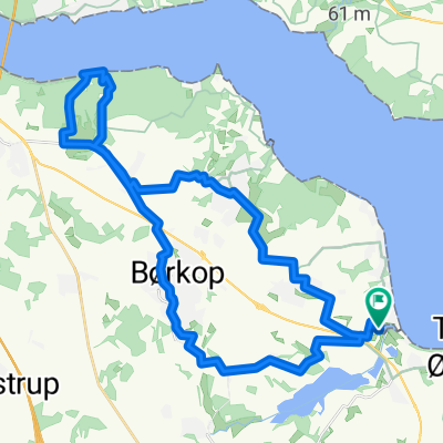
Mørkholt Camping b. Børkop - Løgismose Camping b. Haarby
A cycling route starting in Brejning, Region South Denmark, Denmark.
Overview
About this route
Oslo - Hamburg 2017 Etappe Mørkholt Strand Camping bei Børkop - Løgismose Strand Camping bei Haarby
- -:--
- Duration
- 90.3 km
- Distance
- 251 m
- Ascent
- 257 m
- Descent
- ---
- Avg. speed
- ---
- Max. altitude
Route quality
Waytypes & surfaces along the route
Waytypes
Road
46 km
(51 %)
Quiet road
29.8 km
(33 %)
Surfaces
Paved
84 km
(93 %)
Unpaved
2.7 km
(3 %)
Asphalt
83.1 km
(92 %)
Gravel
2.7 km
(3 %)
Continue with Bikemap
Use, edit, or download this cycling route
You would like to ride Mørkholt Camping b. Børkop - Løgismose Camping b. Haarby or customize it for your own trip? Here is what you can do with this Bikemap route:
Free features
- Save this route as favorite or in collections
- Copy & plan your own version of this route
- Split it into stages to create a multi-day tour
- Sync your route with Garmin or Wahoo
Premium features
Free trial for 3 days, or one-time payment. More about Bikemap Premium.
- Navigate this route on iOS & Android
- Export a GPX / KML file of this route
- Create your custom printout (try it for free)
- Download this route for offline navigation
Discover more Premium features.
Get Bikemap PremiumFrom our community
Other popular routes starting in Brejning
 Dk2
Dk2- Distance
- 70.1 km
- Ascent
- 442 m
- Descent
- 441 m
- Location
- Brejning, Region South Denmark, Denmark
 20230525_BREJNING STRAND HEJLS
- Distance
- 93.4 km
- Ascent
- 763 m
- Descent
- 793 m
- Location
- Brejning, Region South Denmark, Denmark
 Mørkholt Camping b. Børkop - Løgismose Camping b. Haarby
- Distance
- 90.3 km
- Ascent
- 251 m
- Descent
- 257 m
- Location
- Brejning, Region South Denmark, Denmark
 Østkystruten 7
- Distance
- 68.7 km
- Ascent
- 188 m
- Descent
- 194 m
- Location
- Brejning, Region South Denmark, Denmark
 Tur til "Gunnars Dødsrute", Bkool
- Distance
- 93 km
- Ascent
- 299 m
- Descent
- 299 m
- Location
- Brejning, Region South Denmark, Denmark
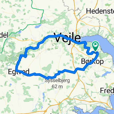
 Fjordparken, Børkop to Fjordparken, Børkop
- Distance
- 35.3 km
- Ascent
- 305 m
- Descent
- 305 m
- Location
- Brejning, Region South Denmark, Denmark
 1. Blans
- Distance
- 106.1 km
- Ascent
- 627 m
- Descent
- 649 m
- Location
- Brejning, Region South Denmark, Denmark
 Egtved
- Distance
- 67.6 km
- Ascent
- 200 m
- Descent
- 200 m
- Location
- Brejning, Region South Denmark, Denmark
Open it in the app