B2B00182 55106 > 55101 vie Johnson Pkwy., Hudson, Kellogg
A cycling route starting in Maplewood, Minnesota, United States of America.
Overview
About this route
Â
Â
- The turn off of Johnson Pkwy. is south on Griffin St. This turns into the frontage road along 94Â called Hudson Ave.
Â
- Kellogg Blvd. - Use caution, heavy traffic.
- -:--
- Duration
- 6.5 km
- Distance
- 46 m
- Ascent
- 80 m
- Descent
- ---
- Avg. speed
- 290 m
- Avg. speed
Route quality
Waytypes & surfaces along the route
Waytypes
Road
2.8 km
(43 %)
Quiet road
1.9 km
(28 %)
Surfaces
Paved
3.6 km
(56 %)
Asphalt
3 km
(46 %)
Concrete
0.6 km
(9 %)
Undefined
2.9 km
(44 %)
Continue with Bikemap
Use, edit, or download this cycling route
You would like to ride B2B00182 55106 > 55101 vie Johnson Pkwy., Hudson, Kellogg or customize it for your own trip? Here is what you can do with this Bikemap route:
Free features
- Save this route as favorite or in collections
- Copy & plan your own version of this route
- Sync your route with Garmin or Wahoo
Premium features
Free trial for 3 days, or one-time payment. More about Bikemap Premium.
- Navigate this route on iOS & Android
- Export a GPX / KML file of this route
- Create your custom printout (try it for free)
- Download this route for offline navigation
Discover more Premium features.
Get Bikemap PremiumFrom our community
Other popular routes starting in Maplewood
- B2B00182 55106 > 55101 vie Johnson Pkwy., Hudson, Kellogg
- Distance
- 6.5 km
- Ascent
- 46 m
- Descent
- 80 m
- Location
- Maplewood, Minnesota, United States of America
- WB CTY PARK
- Distance
- 17.3 km
- Ascent
- 59 m
- Descent
- 71 m
- Location
- Maplewood, Minnesota, United States of America
- Mississippi River Trail (Minnesota)
- Distance
- 35.3 km
- Ascent
- 256 m
- Descent
- 222 m
- Location
- Maplewood, Minnesota, United States of America
- Handsome Cycles
- Distance
- 38.6 km
- Ascent
- 280 m
- Descent
- 300 m
- Location
- Maplewood, Minnesota, United States of America
- B2B00211 55119>55101 via Upper Afton, 7th Street
- Distance
- 17.8 km
- Ascent
- 189 m
- Descent
- 192 m
- Location
- Maplewood, Minnesota, United States of America
- B2B00576 55119>55110 via Upper Afton Rd, Johnson Pkwy, Bruce Vento Trl
- Distance
- 17.1 km
- Ascent
- 74 m
- Descent
- 100 m
- Location
- Maplewood, Minnesota, United States of America
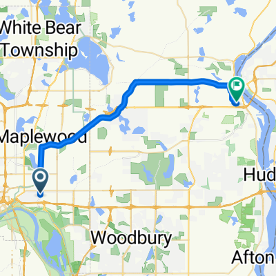
- B2B00784 55125>55164 via Up.Afton/Ruth/Mhaha/JohnsonPkwy/Wheelock/Edgerton/VadLake/Rice/Gramsie/Lex
- Distance
- 27.1 km
- Ascent
- 127 m
- Descent
- 137 m
- Location
- Maplewood, Minnesota, United States of America
- B2B00497 55106>55082 via Bruce Vento Trl, Gateway Trl, Myrtle Av
- Distance
- 28.4 km
- Ascent
- 92 m
- Descent
- 89 m
- Location
- Maplewood, Minnesota, United States of America
Open it in the app