

Vértes tavai
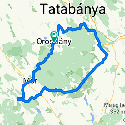
A cycling route starting in Oroszlány, Komárom-Esztergom, Hungary.
Overview
About this route
We are going to see the mining lakes
- -:--
- Duration
- 63.7 km
- Distance
- 483 m
- Ascent
- 483 m
- Descent
- ---
- Avg. speed
- ---
- Max. altitude
Route quality
Waytypes & surfaces along the route
Waytypes
Quiet road
35.7 km
(56 %)
Track
8.9 km
(14 %)
Undefined
19.1 km
(30 %)
Surfaces
Paved
34.4 km
(54 %)
Unpaved
3.8 km
(6 %)
Asphalt
34.4 km
(54 %)
Ground
1.9 km
(3 %)
Continue with Bikemap
Use, edit, or download this cycling route
You would like to ride Vértes tavai or customize it for your own trip? Here is what you can do with this Bikemap route:
Free features
- Save this route as favorite or in collections
- Copy & plan your own version of this route
- Sync your route with Garmin or Wahoo
Premium features
Free trial for 3 days, or one-time payment. More about Bikemap Premium.
- Navigate this route on iOS & Android
- Export a GPX / KML file of this route
- Create your custom printout (try it for free)
- Download this route for offline navigation
Discover more Premium features.
Get Bikemap PremiumFrom our community
Other popular routes starting in Oroszlány
 Oroszlány-Gánt-Kőhányás-Oroszlány
- Distance
- 33.2 km
- Ascent
- 461 m
- Descent
- 462 m
- Location
- Oroszlány, Komárom-Esztergom, Hungary
 From Oroszlány to Pusztavám
- Distance
- 12.8 km
- Ascent
- 111 m
- Descent
- 87 m
- Location
- Oroszlány, Komárom-Esztergom, Hungary
 Vértes kerülő
- Distance
- 101.4 km
- Ascent
- 469 m
- Descent
- 468 m
- Location
- Oroszlány, Komárom-Esztergom, Hungary
 Bánki Donát utca 24, Oroszlány to Bánki Donát utca 22, Oroszlány
- Distance
- 27.8 km
- Ascent
- 118 m
- Descent
- 119 m
- Location
- Oroszlány, Komárom-Esztergom, Hungary
 Oroszlány-Dám kanyar-Oroszlány
- Distance
- 32.1 km
- Ascent
- 374 m
- Descent
- 376 m
- Location
- Oroszlány, Komárom-Esztergom, Hungary
 VérKÖR
- Distance
- 76.1 km
- Ascent
- 1,103 m
- Descent
- 1,104 m
- Location
- Oroszlány, Komárom-Esztergom, Hungary
 edzés 2 villapark
- Distance
- 30.6 km
- Ascent
- 667 m
- Descent
- 675 m
- Location
- Oroszlány, Komárom-Esztergom, Hungary
 Oroszlány-Dunaalmás
- Distance
- 35.6 km
- Ascent
- 28 m
- Descent
- 104 m
- Location
- Oroszlány, Komárom-Esztergom, Hungary
Open it in the app