

20170326_140233.gpx
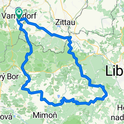
A cycling route starting in Varnsdorf, Ústecký kraj, Czechia.
Overview
About this route
Z Varnsdorfu přes Rumburk,směr Studánka, kolem větrného mlýna do Horního Podluží do Varnsdorfu
- -:--
- Duration
- 31 km
- Distance
- 260 m
- Ascent
- 260 m
- Descent
- ---
- Avg. speed
- ---
- Max. altitude

Route photos


Route quality
Waytypes & surfaces along the route
Waytypes
Quiet road
19.4 km
(63 %)
Track
5.2 km
(17 %)
Surfaces
Paved
18.7 km
(60 %)
Unpaved
4.9 km
(16 %)
Asphalt
18.3 km
(59 %)
Gravel
2.9 km
(9 %)
Continue with Bikemap
Use, edit, or download this cycling route
You would like to ride 20170326_140233.gpx or customize it for your own trip? Here is what you can do with this Bikemap route:
Free features
- Save this route as favorite or in collections
- Copy & plan your own version of this route
- Sync your route with Garmin or Wahoo
Premium features
Free trial for 3 days, or one-time payment. More about Bikemap Premium.
- Navigate this route on iOS & Android
- Export a GPX / KML file of this route
- Create your custom printout (try it for free)
- Download this route for offline navigation
Discover more Premium features.
Get Bikemap PremiumFrom our community
Other popular routes starting in Varnsdorf
 20170326_140233.gpx
- Distance
- 31 km
- Ascent
- 260 m
- Descent
- 260 m
- Location
- Varnsdorf, Ústecký kraj, Czechia
 Na mlýny u Zábrdky
- Distance
- 127.6 km
- Ascent
- 961 m
- Descent
- 965 m
- Location
- Varnsdorf, Ústecký kraj, Czechia
 Na Děvín
- Distance
- 108.2 km
- Ascent
- 1,049 m
- Descent
- 1,043 m
- Location
- Varnsdorf, Ústecký kraj, Czechia
 Na přechody a Královku
- Distance
- 56.1 km
- Ascent
- 389 m
- Descent
- 389 m
- Location
- Varnsdorf, Ústecký kraj, Czechia
 2011-07-16 Harthau-Jeschken-Südumfahrung-Bedrichov-Isergebirge
- Distance
- 143.1 km
- Ascent
- 1,785 m
- Descent
- 1,789 m
- Location
- Varnsdorf, Ústecký kraj, Czechia
 Na rozhledny v Německu IV.
- Distance
- 95.2 km
- Ascent
- 571 m
- Descent
- 562 m
- Location
- Varnsdorf, Ústecký kraj, Czechia
 Na rozhledny v Německu II.
- Distance
- 80.8 km
- Ascent
- 823 m
- Descent
- 817 m
- Location
- Varnsdorf, Ústecký kraj, Czechia
 Na Kottmar a podél Spreevy do Budyšína
- Distance
- 130.8 km
- Ascent
- 732 m
- Descent
- 733 m
- Location
- Varnsdorf, Ústecký kraj, Czechia
Open it in the app