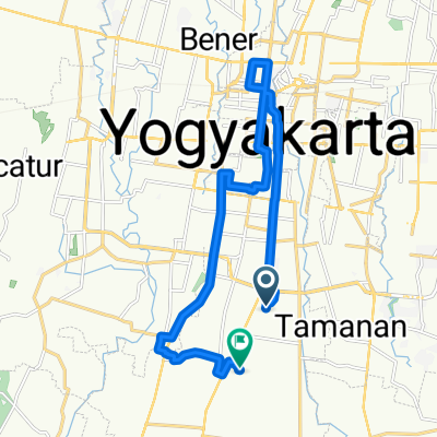
SPSS, 13 February 2010, Sindet Hill Track
A cycling route starting in Sewon, Special Region of Yogyakarta, Indonesia.
Overview
About this route
My latest best XC track!
At first round asphalt let You climb to the highest point, after that journey begin!
Off-road, muddy and slippy track.
9 from 10!
- -:--
- Duration
- 12.8 km
- Distance
- 206 m
- Ascent
- 196 m
- Descent
- ---
- Avg. speed
- 155 m
- Max. altitude
Route quality
Waytypes & surfaces along the route
Waytypes
Quiet road
6.9 km
(54 %)
Busy road
4.6 km
(36 %)
Surfaces
Paved
11.3 km
(89 %)
Asphalt
9.8 km
(77 %)
Paved (undefined)
1 km
(8 %)
Continue with Bikemap
Use, edit, or download this cycling route
You would like to ride SPSS, 13 February 2010, Sindet Hill Track or customize it for your own trip? Here is what you can do with this Bikemap route:
Free features
- Save this route as favorite or in collections
- Copy & plan your own version of this route
- Sync your route with Garmin or Wahoo
Premium features
Free trial for 3 days, or one-time payment. More about Bikemap Premium.
- Navigate this route on iOS & Android
- Export a GPX / KML file of this route
- Create your custom printout (try it for free)
- Download this route for offline navigation
Discover more Premium features.
Get Bikemap PremiumFrom our community
Other popular routes starting in Sewon
- sindet, cembing & koang
- Distance
- 6.9 km
- Ascent
- 173 m
- Descent
- 165 m
- Location
- Sewon, Special Region of Yogyakarta, Indonesia
- Gowes Jembatan Gantung Kedung Miri Sriharjo
- Distance
- 32 km
- Ascent
- 190 m
- Descent
- 189 m
- Location
- Sewon, Special Region of Yogyakarta, Indonesia
- Banguntapan, Bantul to Kasihan, Bantul
- Distance
- 7.6 km
- Ascent
- 23 m
- Descent
- 33 m
- Location
- Sewon, Special Region of Yogyakarta, Indonesia
- Gowes Dewe Jembatan Gantung Imogiri
- Distance
- 47.2 km
- Ascent
- 138 m
- Descent
- 138 m
- Location
- Sewon, Special Region of Yogyakarta, Indonesia
- SPSS, 13 February 2010, Sindet Hill Track
- Distance
- 12.8 km
- Ascent
- 206 m
- Descent
- 196 m
- Location
- Sewon, Special Region of Yogyakarta, Indonesia
- Jalan Giwangan Asri 2 4, Kecamatan Umbulharjo to Jalan Kaliurang 17, Kecamatan Pakem
- Distance
- 24.7 km
- Ascent
- 418 m
- Descent
- 58 m
- Location
- Sewon, Special Region of Yogyakarta, Indonesia
- menurun desa2
- Distance
- 24.9 km
- Ascent
- 367 m
- Descent
- 408 m
- Location
- Sewon, Special Region of Yogyakarta, Indonesia
- Pesona Tamanan Asri, Kecamatan Banguntapan to Mutiara Tamanan 8, Kecamatan Banguntapan
- Distance
- 24.5 km
- Ascent
- 140 m
- Descent
- 143 m
- Location
- Sewon, Special Region of Yogyakarta, Indonesia
Open it in the app