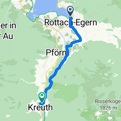
Große Tegernsee Südrunde
- 70.8 km
- 1,874 m
- 1,873 m
- Rottach-Egern, Bavaria, Germany
A cycling route starting in Rottach-Egern, Bavaria, Germany.
Overview
Starting Point: Rottach-Egern or Breitenbach a. Schliersee
Fitness Level: Advanced
Riding Skill: Beginner
Traffic: Low
A partly challenging MTB tour through the mountains between Tegernsee and Schliersee.
From Rottach, the route initially heads up towards the front of Wallberg with 700m of elevation gain at around 14 - 16% average gradient up to the saddle.
Then a fast descent to Enterrottach to tackle the tough Kühzagel climb, which also gains around 300m at roughly 14 - 16% gradient.
From there, the ride continues via the lovely Krainsberger Alm to the Hennerer rest house.
After the path to Gindelalm at Hennerer rest house was nicely leveled, it gets tough on the last 60m with about +20% steepness.
From Gindelalm, the route goes over to Neureuth, where various "summit conquerors with eight-thousanders gear" gather.
The descent from Neureuth House down to Tegernsee will really put your disc brakes to the test - awesome.
Soon after the station, take immediately left uphill through the Alpach valley towards Kreuzberg Alm.
Riders wanting to go all the way up to Kreuzbergalm can do so; otherwise, after a short curve, you should not turn left onto the forest road but continue towards Riederstein.
At Riederstein, you'll be rewarded with a great view and a cozy guesthouse.
created this 8 years ago
Route highlights
Glaslhang - davor vom Tempo runter. Ca. 20% Steigung
Steigung teilweise >= 16% - 17%
Continue with Bikemap
You would like to ride Baumgartenschneid Runde or customize it for your own trip? Here is what you can do with this Bikemap route:
Free trial for 3 days, or one-time payment. More about Bikemap Premium.
Discover more Premium features.
Get Bikemap PremiumFrom our community
Open it in the app