

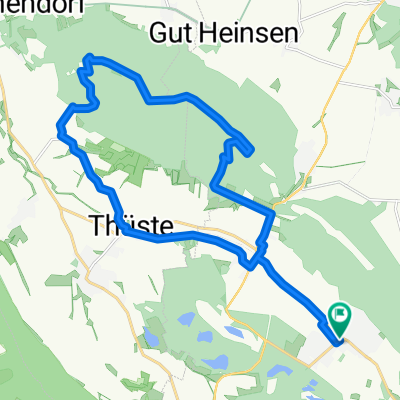
Um die Ithwiesen
A cycling route starting in Duingen, Lower Saxony, Germany.
Overview
About this route
überwiegend gut befestigte Waldwege, außerhalb des Waldes Feldwege mit teilweise sehr grobem Schotter.
- -:--
- Duration
- 18.4 km
- Distance
- 288 m
- Ascent
- 288 m
- Descent
- ---
- Avg. speed
- ---
- Max. altitude
Route quality
Waytypes & surfaces along the route
Waytypes
Track
14.6 km
(79 %)
Busy road
1.6 km
(9 %)
Surfaces
Paved
5.3 km
(29 %)
Unpaved
11.2 km
(61 %)
Gravel
11.2 km
(61 %)
Asphalt
2.7 km
(15 %)
Continue with Bikemap
Use, edit, or download this cycling route
You would like to ride Um die Ithwiesen or customize it for your own trip? Here is what you can do with this Bikemap route:
Free features
- Save this route as favorite or in collections
- Copy & plan your own version of this route
- Sync your route with Garmin or Wahoo
Premium features
Free trial for 3 days, or one-time payment. More about Bikemap Premium.
- Navigate this route on iOS & Android
- Export a GPX / KML file of this route
- Create your custom printout (try it for free)
- Download this route for offline navigation
Discover more Premium features.
Get Bikemap PremiumFrom our community
Other popular routes starting in Duingen
 400-5
400-5- Distance
- 65.7 km
- Ascent
- 505 m
- Descent
- 608 m
- Location
- Duingen, Lower Saxony, Germany
 Duinger Wald-Wilhelm Rabbe Turm
- Distance
- 32.5 km
- Ascent
- 434 m
- Descent
- 432 m
- Location
- Duingen, Lower Saxony, Germany
 Humboldsee Salhemendorf Rundweg
- Distance
- 33.1 km
- Ascent
- 668 m
- Descent
- 667 m
- Location
- Duingen, Lower Saxony, Germany
 Duingen-Lönsturm-Duingen
- Distance
- 22.1 km
- Ascent
- ---
- Descent
- ---
- Location
- Duingen, Lower Saxony, Germany
 Um die Ithwiesen
- Distance
- 18.4 km
- Ascent
- 288 m
- Descent
- 288 m
- Location
- Duingen, Lower Saxony, Germany
 um die Duinger Seeen
- Distance
- 22 km
- Ascent
- 196 m
- Descent
- 198 m
- Location
- Duingen, Lower Saxony, Germany
 Bruchsee zurück
- Distance
- 18.6 km
- Ascent
- 374 m
- Descent
- 403 m
- Location
- Duingen, Lower Saxony, Germany
 Duingen Wald-Roter Fuchs
- Distance
- 32.8 km
- Ascent
- 487 m
- Descent
- 485 m
- Location
- Duingen, Lower Saxony, Germany
Open it in the app