lost river-lac Carling Suroit
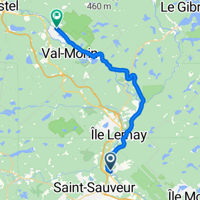
- 117.5 km
- 766 m
- 767 m
- Saint-Sauveur, Quebec, Canada
A cycling route starting in Saint-Sauveur, Quebec, Canada.
Overview
Possibility of cheating via the aerobic corridor (Morin Hight - Lac des Seize-Iles outbound, Montford return)
created this 15 years ago
Route quality
Road
27.7 km
(36 %)
Quiet road
0.8 km
(1 %)
Undefined
48.4 km
(63 %)
Paved
71.5 km
(93 %)
Asphalt
43.8 km
(57 %)
Paved (undefined)
27.7 km
(36 %)
Undefined
5.4 km
(7 %)
Route highlights
Corridor aérobic
Continue with Bikemap
You would like to ride Lost River Vallée de la Rouge or customize it for your own trip? Here is what you can do with this Bikemap route:
Free trial for 3 days, or one-time payment. More about Bikemap Premium.
Discover more Premium features.
Get Bikemap PremiumFrom our community
Open it in the app