

De Madrid a Alcalá
A cycling route starting in San Blas-Canillejas, Madrid, Spain.
Overview
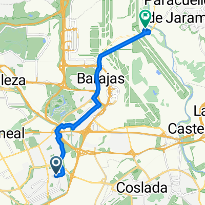
About this route
Coslada proposal for Bici EV14 departure from Madrid to Zaragoza
- -:--
- Duration
- 22.8 km
- Distance
- 79 m
- Ascent
- 185 m
- Descent
- ---
- Avg. speed
- 680 m
- Max. altitude

Route highlights
Points of interest along the route
Point of interest after 0 km
Anillo Ciclista Madrid
Point of interest after 0.2 km
Pasarela a realizar sobre la M-40. Otra posibilidad es hacerla al norte desde el Estadio Metropolitano y llegar al camino de "traperos" por el paso inferios a la M-201 ya existente
Point of interest after 0.8 km
Bajada de "traperos", camino paralelo a la M-201 sin asfaltar.
Point of interest after 1.9 km
Cruce M-201. Previsto semáfono a solicitud

Photo after 2 km
Inicio Carril bici Coslada

Point of interest after 2.3 km
Carril entrada a Coslada

Point of interest after 2.8 km
Carril bici Avenida de España
Point of interest after 3 km
Metro El Puerto (Línea 7)
Point of interest after 3.7 km
Estación Cercanías y Metro Coslada central

Point of interest after 4.8 km
Carril bici Avenida españa
Point of interest after 5.1 km
Final carril bici Av. España Eel siguiente recorrido sería mixto bicis/vehículos a motor y se debería de señalizar)
Point of interest after 5.4 km
Metro La Rambla (línea 7)

Point of interest after 5.5 km
Inicio Carril Coslada (Av. Jesús de San Antonio)

Photo after 6.1 km
Carril bici calle Honduras
Point of interest after 6.8 km
Final Carril Bici Coslada
Point of interest after 6.8 km
San fernando de Henares, zona de tráfico mixto (los tramos de carril bici existentes no reúnen condiciones)

Point of interest after 7.3 km
Carril bici interior parque Dolores Ibarruri
Point of interest after 7.4 km
Inicio carril bici parque Dolores Ibarruri)

Photo after 8.3 km
Paseo de los Chopos. Peatonal y ciclista

Point of interest after 10.3 km
Puente del Moco (peatonal y ciclista

Point of interest after 10.6 km
Entrada al parque regional del sureste, pista de grava ain asfaltar
Point of interest after 12.4 km
Cañada real
Point of interest after 14.1 km
Camino del antiguo tren de la Azucarera (grava)

Photo after 15.6 km
Palacio de Aldovea
Point of interest after 16.4 km
Carretera del Castillo (asfaltada, compartida con vehículos a motor

Photo after 17.2 km
Paso superor por paso de cebra compartido con peatones hasta inicio del carril bici

Photo after 17.3 km
Paso inferior, junto al río, sin asfaltar

Point of interest after 18.1 km
Carril bici Parque Europa

Photo after 20 km
Carril bici Miradores
Point of interest after 21.1 km
Inicio caminos vega del Torote (sin Asfaltar)
Point of interest after 22.8 km
Entrada a Alcalá de Henares.

Point of interest after 22.8 km
Necesidad de un paso ciclo/peatronal sobre el arroyo Torote
Continue with Bikemap
Use, edit, or download this cycling route
You would like to ride De Madrid a Alcalá or customize it for your own trip? Here is what you can do with this Bikemap route:
Free features
- Save this route as favorite or in collections
- Copy & plan your own version of this route
- Sync your route with Garmin or Wahoo
Premium features
Free trial for 3 days, or one-time payment. More about Bikemap Premium.
- Navigate this route on iOS & Android
- Export a GPX / KML file of this route
- Create your custom printout (try it for free)
- Download this route for offline navigation
Discover more Premium features.
Get Bikemap PremiumFrom our community
Other popular routes starting in San Blas-Canillejas
 De Calle de Julia García Boután a Calle Miguel de Cervantes
- Distance
- 12.9 km
- Ascent
- 49 m
- Descent
- 190 m
- Location
- San Blas-Canillejas, Madrid, Spain
 Aeropuerto
- Distance
- 43.7 km
- Ascent
- 204 m
- Descent
- 204 m
- Location
- San Blas-Canillejas, Madrid, Spain
 Paracaellos de Jara
- Distance
- 39.1 km
- Ascent
- 304 m
- Descent
- 304 m
- Location
- San Blas-Canillejas, Madrid, Spain
 Casa - Ofi
- Distance
- 2.1 km
- Ascent
- 68 m
- Descent
- 83 m
- Location
- San Blas-Canillejas, Madrid, Spain
 anillo ciclista madrid. este norte oeste
- Distance
- 26.8 km
- Ascent
- 191 m
- Descent
- 235 m
- Location
- San Blas-Canillejas, Madrid, Spain
 Caja Mágica, camino Uclés, Rivas, Vicalvaro
- Distance
- 52.4 km
- Ascent
- 220 m
- Descent
- 224 m
- Location
- San Blas-Canillejas, Madrid, Spain
 Ruta14-06-2015
- Distance
- 61.8 km
- Ascent
- 364 m
- Descent
- 365 m
- Location
- San Blas-Canillejas, Madrid, Spain
 De Madrid a Alcalá
- Distance
- 22.8 km
- Ascent
- 79 m
- Descent
- 185 m
- Location
- San Blas-Canillejas, Madrid, Spain
Open it in the app