

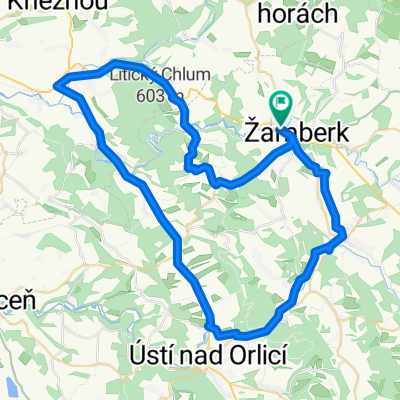
Žamberk-Letohrad-Ústí-Brandýs-Choceň-Žďár
A cycling route starting in Žamberk, Pardubický kraj, Czechia.
Overview
About this route
Žamberk-Letohrad-Ústí-Brandýs-Choceň-Žďár
- -:--
- Duration
- 63.5 km
- Distance
- 186 m
- Ascent
- 346 m
- Descent
- ---
- Avg. speed
- ---
- Max. altitude

Route quality
Waytypes & surfaces along the route
Waytypes
Cycleway
21.6 km
(34 %)
Quiet road
7 km
(11 %)
Surfaces
Paved
41.3 km
(65 %)
Unpaved
1.9 km
(3 %)
Asphalt
41.3 km
(65 %)
Gravel
1.3 km
(2 %)
Continue with Bikemap
Use, edit, or download this cycling route
You would like to ride Žamberk-Letohrad-Ústí-Brandýs-Choceň-Žďár or customize it for your own trip? Here is what you can do with this Bikemap route:
Free features
- Save this route as favorite or in collections
- Copy & plan your own version of this route
- Sync your route with Garmin or Wahoo
Premium features
Free trial for 3 days, or one-time payment. More about Bikemap Premium.
- Navigate this route on iOS & Android
- Export a GPX / KML file of this route
- Create your custom printout (try it for free)
- Download this route for offline navigation
Discover more Premium features.
Get Bikemap PremiumFrom our community
Other popular routes starting in Žamberk
 Žamberk-Letohrad-Ústí-Brandýs-Choceň-Žďár
- Distance
- 63.5 km
- Ascent
- 186 m
- Descent
- 346 m
- Location
- Žamberk, Pardubický kraj, Czechia
 Žamberk - Tyršova rozhledna
- Distance
- 2.3 km
- Ascent
- 68 m
- Descent
- 9 m
- Location
- Žamberk, Pardubický kraj, Czechia
 Žamberk - Suchý vrch - Svatá Trojice - Morava - Červená Voda - Žamberk
- Distance
- 124.6 km
- Ascent
- 2,266 m
- Descent
- 2,266 m
- Location
- Žamberk, Pardubický kraj, Czechia
 Žamberk-Šerlich_36-27-Žďár
- Distance
- 83.7 km
- Ascent
- 1,181 m
- Descent
- 1,339 m
- Location
- Žamberk, Pardubický kraj, Czechia
 bike tour through Žamberk
- Distance
- 23.1 km
- Ascent
- 219 m
- Descent
- 228 m
- Location
- Žamberk, Pardubický kraj, Czechia
 Žamberk-Letohrad-Písečná
- Distance
- 21.3 km
- Ascent
- 183 m
- Descent
- 183 m
- Location
- Žamberk, Pardubický kraj, Czechia
 Orlické hory
- Distance
- 98.1 km
- Ascent
- 1,719 m
- Descent
- 1,723 m
- Location
- Žamberk, Pardubický kraj, Czechia
 Žamberk->Letohrad->Ústí n. O.->Vamberk->Česká rybná->Žamberk
- Distance
- 59.6 km
- Ascent
- 491 m
- Descent
- 497 m
- Location
- Žamberk, Pardubický kraj, Czechia
Open it in the app