Pętla Św
A cycling route starting in Sandomierz, Świętokrzyskie Voivodship, Poland.
Overview
About this route
- -:--
- Duration
- 202.7 km
- Distance
- 567 m
- Ascent
- 470 m
- Descent
- ---
- Avg. speed
- ---
- Max. altitude
Route quality
Waytypes & surfaces along the route
Waytypes
Quiet road
79 km
(39 %)
Road
70.9 km
(35 %)
Surfaces
Paved
147.9 km
(73 %)
Unpaved
16.2 km
(8 %)
Asphalt
141.9 km
(70 %)
Unpaved (undefined)
8.1 km
(4 %)
Route highlights
Points of interest along the route

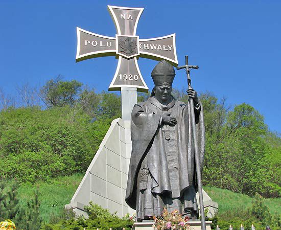
Point of interest after 0 km
Pomnik Jana Pawła II

Point of interest after 3.9 km
Punkt widokowy Góry Pieprzowe

Point of interest after 17.9 km
Pomnik Zawiszy Czarnego

Point of interest after 27.3 km
Wodowskaz Zawichost

Point of interest after 34.7 km
Pałac w Czyżowie Szlacheckim

Point of interest after 54.9 km
XVI wieczny drewniany kościół parafialny pw. Świętego Wojciecha

Point of interest after 55.2 km
Zabytkowa drewniana studnia z 1880 roku

Point of interest after 64.2 km
Cmentarz wojenny z okresu II wojny światowej

Point of interest after 75.7 km
Bałtów

Point of interest after 82 km
Krzemionki Opatowskie

Point of interest after 91.4 km
Ostrowiec Św

Point of interest after 106.7 km
Nietulisko Fabryczne

Point of interest after 112.7 km
Tama Wióry

Point of interest after 114.6 km
Sanktuarium w Kałkowie

Point of interest after 138.4 km
Rezerwat Wykus

Point of interest after 145.2 km
Wąchock - pomnik Sołtysa

Point of interest after 162 km
Muzeum Orła Białego w Skarżysku-Kamiennym
Continue with Bikemap
Use, edit, or download this cycling route
You would like to ride Pętla Św or customize it for your own trip? Here is what you can do with this Bikemap route:
Free features
- Save this route as favorite or in collections
- Copy & plan your own version of this route
- Split it into stages to create a multi-day tour
- Sync your route with Garmin or Wahoo
Premium features
Free trial for 3 days, or one-time payment. More about Bikemap Premium.
- Navigate this route on iOS & Android
- Export a GPX / KML file of this route
- Create your custom printout (try it for free)
- Download this route for offline navigation
Discover more Premium features.
Get Bikemap PremiumFrom our community
Other popular routes starting in Sandomierz
 HOBBY Cyklokarpaty.pl Sandomierz 2016
- Distance
- 21.2 km
- Ascent
- 274 m
- Descent
- 250 m
- Location
- Sandomierz, Świętokrzyskie Voivodship, Poland
 Kazimierz Dolny-Nałęczów.
- Distance
- 218 km
- Ascent
- 495 m
- Descent
- 497 m
- Location
- Sandomierz, Świętokrzyskie Voivodship, Poland
 Sandomierz MTB Family
- Distance
- 13.2 km
- Ascent
- 203 m
- Descent
- 202 m
- Location
- Sandomierz, Świętokrzyskie Voivodship, Poland
 Wyprawa na Mazury 2014
- Distance
- 1,247.2 km
- Ascent
- 592 m
- Descent
- 596 m
- Location
- Sandomierz, Świętokrzyskie Voivodship, Poland
 Sandomierskie Krajobrazy - szlak żółty
- Distance
- 19.4 km
- Ascent
- 22 m
- Descent
- 22 m
- Location
- Sandomierz, Świętokrzyskie Voivodship, Poland
 Wycieczka w Pieniny.
- Distance
- 554.2 km
- Ascent
- 857 m
- Descent
- 859 m
- Location
- Sandomierz, Świętokrzyskie Voivodship, Poland
 3 dzień SANDOMIERZ - BIŁGORAJ GVelo
- Distance
- 102.1 km
- Ascent
- 157 m
- Descent
- 149 m
- Location
- Sandomierz, Świętokrzyskie Voivodship, Poland
 3-cio majowa trasa.
- Distance
- 76.4 km
- Ascent
- 134 m
- Descent
- 132 m
- Location
- Sandomierz, Świętokrzyskie Voivodship, Poland
Open it in the app

