

Carrera Quillota Tricentenario - Sector Oriente
A cycling route starting in Quillota, Región de Valparaíso, Chile.
Overview
About this route
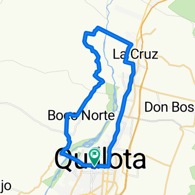
Route that runs through the beautiful eastern sectors of our city of Quillota. It starts in the locality of La Palma and continues towards San Isidro, then advances along the highway service road to reach stop 8 where it rises to the La Puntilla area. From there, it proceeds towards Pocochay, giving a nod to the city of La Cruz, and finally returns along the hillside back to the start of the route. It has a slight elevation gain of 120 meters, being practically flat.
- -:--
- Duration
- 31.8 km
- Distance
- 138 m
- Ascent
- 138 m
- Descent
- ---
- Avg. speed
- ---
- Max. altitude

Continue with Bikemap
Use, edit, or download this cycling route
You would like to ride Carrera Quillota Tricentenario - Sector Oriente or customize it for your own trip? Here is what you can do with this Bikemap route:
Free features
- Save this route as favorite or in collections
- Copy & plan your own version of this route
- Sync your route with Garmin or Wahoo
Premium features
Free trial for 3 days, or one-time payment. More about Bikemap Premium.
- Navigate this route on iOS & Android
- Export a GPX / KML file of this route
- Create your custom printout (try it for free)
- Download this route for offline navigation
Discover more Premium features.
Get Bikemap PremiumFrom our community
Other popular routes starting in Quillota
 Carrera Quillota Tricentenario - Sector Oriente
- Distance
- 31.8 km
- Ascent
- 138 m
- Descent
- 138 m
- Location
- Quillota, Región de Valparaíso, Chile
 De Pudeto 561, Quillota a Carrera 465, Quillota
- Distance
- 22.7 km
- Ascent
- 181 m
- Descent
- 182 m
- Location
- Quillota, Región de Valparaíso, Chile
 De Carrera 405, Quillota a Carrera 449, Quillota
- Distance
- 29.6 km
- Ascent
- 131 m
- Descent
- 133 m
- Location
- Quillota, Región de Valparaíso, Chile
 Ruta a Juan Bautista Alberdi 1151, Quillota
- Distance
- 18.3 km
- Ascent
- 111 m
- Descent
- 131 m
- Location
- Quillota, Región de Valparaíso, Chile
 Recorriendo parte de la V región
- Distance
- 116.9 km
- Ascent
- 1,235 m
- Descent
- 1,237 m
- Location
- Quillota, Región de Valparaíso, Chile
 De Libertad 406, Quillota a Pasaje 5 1650, Quillota
- Distance
- 14.8 km
- Ascent
- 158 m
- Descent
- 185 m
- Location
- Quillota, Región de Valparaíso, Chile
 Pisagua 347–399, Santa Rosa to Puente Colmo, Quillota
- Distance
- 15.4 km
- Ascent
- 106 m
- Descent
- 148 m
- Location
- Quillota, Región de Valparaíso, Chile
 De Esmeralda 2, Quillota a Los Lúcumos 1, Quillota
- Distance
- 35.3 km
- Ascent
- 597 m
- Descent
- 577 m
- Location
- Quillota, Región de Valparaíso, Chile
Open it in the app