
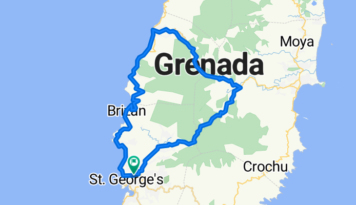
St Georges to Grand Etang, return via Belvedere, Clozier, Gouyave
A cycling route starting in St. George's, Saint George Parish, Grenada.
Overview
About this route
This route starts with the 1,900ft climb up Grand Etang - not for the faint hearted with the last mile at an average of at least 13% - in parts to 20%. Descend to turn off to Belvedere. This is a concrete road through agricultural land and rain forest. It also climbs and descends alarmingly - mostly shorter climbs but up to at least 25% in places. Over Clozier then a steep descent to Gouyave - watch out the gradient is steep and changes rapidly all the way down, not great road surface either. A tough ride with 4,000ft of ascent over 25 miles.
- -:--
- Duration
- 44.7 km
- Distance
- 1,485 m
- Ascent
- 1,472 m
- Descent
- ---
- Avg. speed
- 589 m
- Max. altitude

Route quality
Waytypes & surfaces along the route
Waytypes
Quiet road
3.6 km
(8 %)
Access road
0.9 km
(2 %)
Surfaces
Paved
38 km
(85 %)
Asphalt
37.6 km
(84 %)
Concrete
0.4 km
(1 %)
Undefined
6.7 km
(15 %)
Continue with Bikemap
Use, edit, or download this cycling route
You would like to ride St Georges to Grand Etang, return via Belvedere, Clozier, Gouyave or customize it for your own trip? Here is what you can do with this Bikemap route:
Free features
- Save this route as favorite or in collections
- Copy & plan your own version of this route
- Sync your route with Garmin or Wahoo
Premium features
Free trial for 3 days, or one-time payment. More about Bikemap Premium.
- Navigate this route on iOS & Android
- Export a GPX / KML file of this route
- Create your custom printout (try it for free)
- Download this route for offline navigation
Discover more Premium features.
Get Bikemap PremiumFrom our community
Other popular routes starting in St. George's
 Grand Anse circuit - very steep climbs
- Distance
- 14.5 km
- Ascent
- 469 m
- Descent
- 456 m
- Location
- St. George's, Saint George Parish, Grenada
 St Georges to Grand Etang, return via Belvedere, Clozier, Gouyave
- Distance
- 44.7 km
- Ascent
- 1,485 m
- Descent
- 1,472 m
- Location
- St. George's, Saint George Parish, Grenada
 The cliff to Westerhall, St Pauls, return via Morne Jaloux, Springs and Golf Course
- Distance
- 20.7 km
- Ascent
- 597 m
- Descent
- 629 m
- Location
- St. George's, Saint George Parish, Grenada
 Grenada Round 2
- Distance
- 43 km
- Ascent
- 541 m
- Descent
- 543 m
- Location
- St. George's, Saint George Parish, Grenada
 Port Louis Marina - Westerhall - St Davids - Grenville - return via Grand Etang
- Distance
- 55.5 km
- Ascent
- 1,405 m
- Descent
- 1,237 m
- Location
- St. George's, Saint George Parish, Grenada
 Port Louis Marina - Morne Jaloux Ridge - Wobburn and return via Springs
- Distance
- 14.1 km
- Ascent
- 373 m
- Descent
- 370 m
- Location
- St. George's, Saint George Parish, Grenada
 MTB circuit Annandale - Willis
- Distance
- 4.3 km
- Ascent
- 151 m
- Descent
- 151 m
- Location
- St. George's, Saint George Parish, Grenada
 Annandale mountain bike circuit
- Distance
- 4.9 km
- Ascent
- 192 m
- Descent
- 189 m
- Location
- St. George's, Saint George Parish, Grenada
Open it in the app