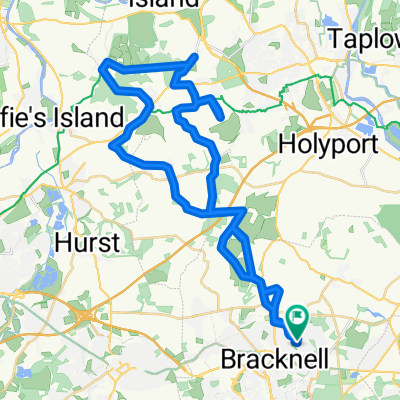
Swinley Forest Blue Route
A cycling route starting in Bracknell, England, United Kingdom.
Overview
About this route
- -:--
- Duration
- 8.5 km
- Distance
- 50 m
- Ascent
- 47 m
- Descent
- ---
- Avg. speed
- ---
- Max. altitude
Continue with Bikemap
Use, edit, or download this cycling route
You would like to ride Swinley Forest Blue Route or customize it for your own trip? Here is what you can do with this Bikemap route:
Free features
- Save this route as favorite or in collections
- Copy & plan your own version of this route
- Sync your route with Garmin or Wahoo
Premium features
Free trial for 3 days, or one-time payment. More about Bikemap Premium.
- Navigate this route on iOS & Android
- Export a GPX / KML file of this route
- Create your custom printout (try it for free)
- Download this route for offline navigation
Discover more Premium features.
Get Bikemap PremiumFrom our community
Other popular routes starting in Bracknell
- Easy ride in Bracknell
- Distance
- 3.6 km
- Ascent
- 175 m
- Descent
- 168 m
- Location
- Bracknell, England, United Kingdom
- BracknelltoNewburyandBack
- Distance
- 94.3 km
- Ascent
- 296 m
- Descent
- 296 m
- Location
- Bracknell, England, United Kingdom
- Moderate route in Bracknell
- Distance
- 8.5 km
- Ascent
- 203 m
- Descent
- 199 m
- Location
- Bracknell, England, United Kingdom
- Cycle Surgery Special
- Distance
- 26.9 km
- Ascent
- 131 m
- Descent
- 174 m
- Location
- Bracknell, England, United Kingdom
- Bracknell to crazies hill and know hill
- Distance
- 46 km
- Ascent
- 218 m
- Descent
- 218 m
- Location
- Bracknell, England, United Kingdom
- 3 Counties Cycle Route (80 km)
- Distance
- 82.5 km
- Ascent
- 378 m
- Descent
- 379 m
- Location
- Bracknell, England, United Kingdom
- Short bike tour from 26/02/2016, 14:38
- Distance
- 8.8 km
- Ascent
- 57 m
- Descent
- 57 m
- Location
- Bracknell, England, United Kingdom
- Swinley Forest Blue Route
- Distance
- 8.5 km
- Ascent
- 50 m
- Descent
- 47 m
- Location
- Bracknell, England, United Kingdom
Open it in the app