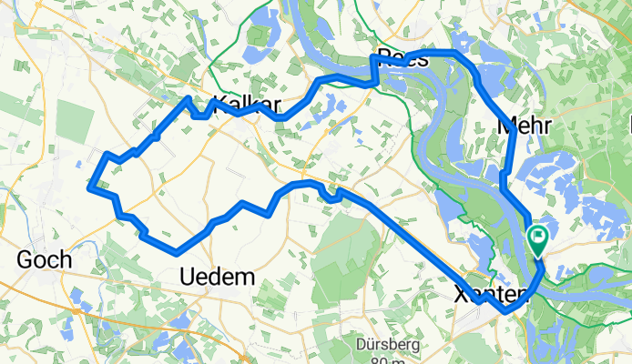
Touren mit "Keer Tröch"-Überfahrt
Bislich Keppeln Kalkar Rees
A cycling route starting in Xanten, North Rhine-Westphalia, Germany.
Overview
About this route
RUNDTOUR: Pay attention to the passenger ferry 'Keer Tröch' schedules!! Tour through the city of Kalkar (beautiful city center) and the Rhine town of Rees (very nice Rhine promenade)
- -:--
- Duration
- 63.5 km
- Distance
- 61 m
- Ascent
- 63 m
- Descent
- ---
- Avg. speed
- ---
- Max. altitude
Part of
19 stages
Route quality
Waytypes & surfaces along the route
Waytypes
Quiet road
24.1 km
(38 %)
Path
20.3 km
(32 %)
Surfaces
Paved
34.3 km
(54 %)
Asphalt
32.4 km
(51 %)
Paved (undefined)
1.9 km
(3 %)
Undefined
29.2 km
(46 %)
Continue with Bikemap
Use, edit, or download this cycling route
You would like to ride Bislich Keppeln Kalkar Rees or customize it for your own trip? Here is what you can do with this Bikemap route:
Free features
- Save this route as favorite or in collections
- Copy & plan your own version of this route
- Sync your route with Garmin or Wahoo
Premium features
Free trial for 3 days, or one-time payment. More about Bikemap Premium.
- Navigate this route on iOS & Android
- Export a GPX / KML file of this route
- Create your custom printout (try it for free)
- Download this route for offline navigation
Discover more Premium features.
Get Bikemap PremiumFrom our community
Other popular routes starting in Xanten
- Bislich Kalkar
- Distance
- 48.1 km
- Ascent
- 24 m
- Descent
- 16 m
- Location
- Xanten, North Rhine-Westphalia, Germany
- Marienbaum, Rees, Bislich, Xanten, Marienbaum
- Distance
- 38.7 km
- Ascent
- 55 m
- Descent
- 55 m
- Location
- Xanten, North Rhine-Westphalia, Germany
- Alpen-Xanten Rundtour Spargelhof
- Distance
- 36.1 km
- Ascent
- 85 m
- Descent
- 85 m
- Location
- Xanten, North Rhine-Westphalia, Germany
- Bislich Ringenberg
- Distance
- 52.4 km
- Ascent
- 50 m
- Descent
- 46 m
- Location
- Xanten, North Rhine-Westphalia, Germany
- Xanten Highlight
- Distance
- 23.5 km
- Ascent
- 69 m
- Descent
- 72 m
- Location
- Xanten, North Rhine-Westphalia, Germany
- Xanten-Wesel-Xanten
- Distance
- 26.5 km
- Ascent
- 60 m
- Descent
- 60 m
- Location
- Xanten, North Rhine-Westphalia, Germany
- Vynen Xanten
- Distance
- 19.1 km
- Ascent
- 31 m
- Descent
- 27 m
- Location
- Xanten, North Rhine-Westphalia, Germany
- Xanten-Rheinberg-Xanten
- Distance
- 45.6 km
- Ascent
- 34 m
- Descent
- 32 m
- Location
- Xanten, North Rhine-Westphalia, Germany
Open it in the app